HAWTHORNE
JACK NORTHROP FLD/HAWTHORNE MUNI (HHR)(KHHR) 1 E UTC–8(–7DT) N33°55.37′ W118°20.11′ 66 B TPA–See Remarks NOTAM FILE HHR
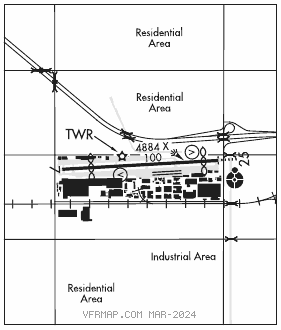
RWY 07–25: H4884X100 (ASPH) S–30, D–60, 2D–90 MIRL IAP, AD
RWY07: VASI(V2R)–GA 3.25° TCH 25′. Thld dsplcd 905′. Road. Rgt tfc.
RWY 25: ODALS. REIL. VASI(V4R)–GA 3.5° TCH 26′. Thld dsplcd 460′. Pole.
RUNWAY DECLARED DISTANCE INFORMATION
RWY 07: TORA–4956 TODA–4956 ASDA–4736 LDA–3765
RWY 25: TORA–4956 TODA–4956 ASDA–4656 LDA–4193
SERVICE: S4 FUEL 100LL, JET A OX 1, 3 LGT When twr clsd ACTIVATE MIRL Rwy 07–25 and ODALS Rwy 25–CTAF.
NOISE: Rwy 25 touch and go, stop and go, and int tkofs are rqstd to be airborne by D twy. Hover work ltd to N twy btn C and D twys. All piston acft must be equipped with muffler sys. For noise abatement info ctc arpt supervisor (310) 349–1637 or 1636.
AIRPORTREMARKS:Attended 1300–0600Z‡ Mon–Fri, 1400–0500Z‡ Sat, 1400–0600Z‡ Sun. Numerous flocks of birds on and invof arpt. 100LL fuel avbl 24 hrs self svc. Jet A fuel avbl 1300–0600Z‡ Mon–Fri, 1400–0500Z‡ Sat, 1400–0600Z‡ Sun, after hrs call 310–676–4673 or 310–644–0400. Be alert to 8′ blast fence AER 25. Touch and go ldgs, stop and go ldgs and low apch ops for all acft including helicopters ltd to 1800–0100Z‡. No formation tkofs auth. No pat opns, no taxi–back ops Mon–Fri 0600–1600Z‡, Sat–Sun 0600–1800Z‡. TPA for turbine/high performance acft 1600 (1534), lgt acft 1100 (1034), helicopters 700(634). N twy west of E twy designated non–movement area. Rwy 25 runup south of S twy 900′ west of AER 25.
AIRPORT MANAGER: 310-349-1637
WEATHER DATA SOURCES: ASOS (310) 973–8930
COMMUNICATIONS: CTAF 121.1 ATIS 118.4 310–675–7945
®SOCAL APP CON 124.3 (146°–245° HHR) 124.9 (069°–145° LAX) 125.2 (246°–342° LAX) 128.5 (343°–068°)
TOWER 121.1 (1400–0600Z‡) GND CON 125.1
®SOCAL DEP CON 124.3
CLEARANCE DELIVERY PHONE: For CD when ATCT clsd ctc SoCal Apch at 800-448-3724.
AIRSPACE: CLASS D svc 1400–0600Z‡; other times CLASS G.
VOR TEST FACILITY (VOT) 113.9
RADIO AIDS TO NAVIGATION: NOTAM FILE LAX.
LOS ANGELES (VH) (H) VORTACW 113.6 LAX Chan 83 N33°55.99′ W118°25.92′ 082° 4.9 NM to fld. 185/15E.
VOR unusable:
004°–014° byd 40 NM blo 12,000′
004°–014° byd 51 NM
015°–053° byd 40 NM
060°–081° byd 40 NM blo 4,500′
060°–081° byd 58 NM blo 14,000′
060°–081° byd 65 NM
082°–101° byd 40 NM
109°–115° byd 40 NM
138°–155° byd 40 NM
175°–205° byd 10 NM blo 3,000′
270°–277° byd 25 NM blo 8,000′
276°–329° byd 40 NM
277°–300° byd 10 NM blo 8,000′
277°–300° byd 28 NM blo 12,000′
341°–003° byd 40 NM
LOC 109.1 I–HHR Rwy 25. LOC unusable byd 15° right of course; byd 20° left of course; wi 0.8 NM inbd. Unmonitored when ATCT clsd.