SOUTH TEXAS RGNL AT HONDO (HDO)(KHDO) 2 NW UTC–6(–5DT) N29°21.55′ W99°10.65′
930 B TPA—1730(800) NOTAM FILE HDO
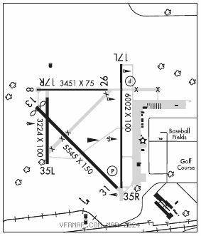
RWY 17L–35R: H6002X100 (CONC) S–30, D–45, 2D–90 PCN 103R/C/W/T MIRL 0.3% up N
RWY 17L: PAPI(P4L)—GA 3.0° TCH 45′.
RWY 35R: PAPI(P4L)—GA 3.0° TCH 45′. Rgt tfc.
RWY 13–31: H5545X150 (CONC) S–30, D–45, 2D–90 0.3% up NW
RWY 13: Thld dsplcd 98′. Rgt tfc.
RWY 08–26: H3451X75 (CONC) S–30, D–45, 2D–90
RWY 17R–35L: H3224X140 (ASPH) S–30, D–45, 2D–90 0.3% up N
RWY 17R: Rgt tfc.
SERVICE: S2 FUEL 100LL, JET A
AIRPORT REMARKS: Attended Mon–Fri 1330–2300Z‡. Deer on and invof arpt. 100LL 24 hr self serve. Full serve Jet A and AVGAS on request, 830–426–3810. 2 hr prior notice, aft hrs. Rwy 08–26 width is 75′ unmarked, overall pavement width is 150′. Bring own ropes for tie down. NOTE: See Special Notices—Unmanned Aircraft System Activity.
AIRPORT MANAGER: 830-426-3810
WEATHER DATA SOURCES: ASOS 119.675 (830) 426–3060.
COMMUNICATIONS: CTAF/UNICOM 122.725
®HOUSTON CENTER APP/DEP CON 134.95
CLEARANCE DELIVERY PHONE: For CD ctc Houston ARTCC at 281-230-5622.
RADIO AIDS TO NAVIGATION: NOTAM FILE SAT.
SAN ANTONIO (VH) (H) VORTACW 116.8 SAT Chan 115 N29°38.64′ W98°27.68′ 238° 41.2 NM to fld. 1159/8E.
VOR unusable:
018°–022° byd 40 NM
028°–032° byd 40 NM
342°–347° byd 40 NM
355°–002° byd 40 NM blo 18,000′