JIM HOGG CO (HBV)(KHBV) 3 NW UTC–6(–5DT) N27°20.97′ W98°44.22′
663 B NOTAM FILE HBV
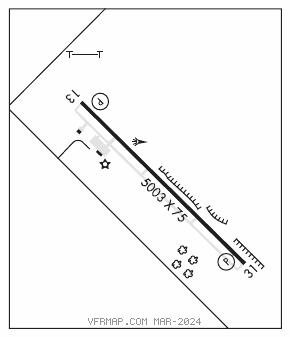
RWY 13–31: H5003X75 (ASPH) S–30, D–72, 2S–91 MIRL
RWY 13: PAPI(P2L)—GA 3.0° TCH 39′. Trees.
RWY 31: PAPI(P2L)—GA 3.0° TCH 43′. Tree.
SERVICE: FUEL JET A LGT MIRL Rwy 13–31 preset low intst; to incr intst ACTVT—CTAF. PAPI Rwy 13 oprs consly.
AIRPORT REMARKS: Unattended. Attendant on call. For jet A, call 361–850–3430. Rwy 13–31 gross weight pavement strength provided by arpt manager. Large acft exiting Rwy 31 should back taxi on rwy due to obstn on twy.
AIRPORT MANAGER: 956-693-7751
WEATHER DATA SOURCES: AWOS–3 118.075 (361) 527–2109. Ceiling not avbl.
COMMUNICATIONS: CTAF/UNICOM 122.8
®HOUSTON CENTER APP/DEP CON 127.8
CLEARANCE DELIVERY PHONE: For CD ctc Houston ARTCC at 281-230-5622.
RADIO AIDS TO NAVIGATION: NOTAM FILE LRD.
LAREDO (VH) (H) VORTACW 117.4 LRD Chan 121 N27°28.72′ W99°25.06′ 093° 37.2 NM to fld. 583/9E.
VOR unusable:
080°–126° byd 40 NM
127°–137° byd 40 NM blo 4,500′
127°–137° byd 56 NM
138°–148° byd 57 NM
190°–260° byd 40 NM