NORTH TEXAS RGNL/PERRIN FLD (GYI)(KGYI) 4 W UTC–6(–5DT) N33°42.85′ W96°40.46′
749 B NOTAM FILE GYI
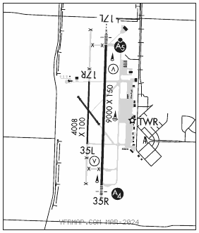
RWY 17L–35R: H9000X150 (ASPH–CONC) S–75, D–100, 2S–127, 2D–160 MIRL
RWY 17L: MALSR. VASI(V4L)—GA 3.0° TCH 48′.
RWY 35R: MALS. VASI(V4L)—GA 3.0° TCH 51′.
RWY 17R–35L: H4008X100 (ASPH–CONC)
RWY 13–31: H2277X60 (ASPH)
SERVICE: S4 FUEL 100LL, JET A OX 3 LGT Dusk–Dawn. MIRL Rwy 17L–35R preset low intst, to incr intst and ACTVT MALSR Rwy 17L and MALS Rwy 35R—CTAF.
AIRPORT REMARKS: Attended 1300–0100Z‡. 100LL self serve. For fuel after hours call 903–786–2666; call–in fee. Rwy 17L dsgnd calm wind rwy. Txy mkgs and hold lines faded. Rwy 13–31 CLOSED permly. Extsv cracking and loose grvl. NOTE: See Special Notices—Aerobatic Practice Area.
AIRPORT MANAGER: 903-786-2904
WEATHER DATA SOURCES: AWOS–3 118.775 (903) 786–7790.
COMMUNICATIONS: CTAF 120.575 ATIS 118.775
SHERMAN/DENISON RCO 122.3 (FORT WORTH RADIO)
®FORT WORTH CENTER APP/DEP CON 124.75
TOWER 120.575 (1300–0100Z‡) GND CON 124.125
CLEARANCE DELIVERY PHONE: For CD if una to ctc on FSS freq, ctc Fort Worth ARTCC at 817-858-7584.
AIRSPACE: CLASS D svc 1300–0100Z‡; other times CLASS G.
RADIO AIDS TO NAVIGATION: NOTAM FILE FTW.
BONHAM (VH) (H) VORTACW 114.6 BYP Chan 93 N33°32.25′ W96°14.05′ 290° 24.5 NM to fld. 700/6E.
DENISON NDB (MHW) 341 DNI N33°49.59′ W96°40.13′ 176° 6.7 NM to fld. 642/6E. NOTAM FILE GYI.
ILS 111.7 I–GYI Rwy 17L. Class IT. LOC unusable byd 25° right of course. Glideslope autocoupled approaches na blw 1,900′ MSL.