GEORGETOWN EXEC (GTU)(KGTU) 3 N UTC–6(–5DT) N30°40.73′ W97°40.76′
790 B NOTAM FILE GTU
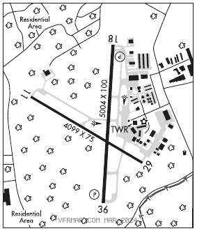
RWY 18–36: H5004X100 (ASPH–GRVD) S–30, D–60 MIRL 0.8% up N
RWY 18: REIL. PAPI(P4L)—GA 3.0° TCH 35′. Trees.
RWY 36: REIL. PAPI(P4L)—GA 3.0° TCH 50′. Trees. Rgt tfc.
RWY 11–29: H4099X75 (ASPH) S–12.5 MIRL 0.7% up NW
RWY 11: Tree.
RWY 29: Tree. Rgt tfc.
SERVICE: S4 FUEL 100LL, JET A1+ OX 1, 2, 3, 4 LGT Aftr twr hrs, MIRL Rwy 18–36 preset low intst; to incr intst and actvt REILS Rwy 18–36 and MIRL Rwy 11–29—CTAF. PAPI Rwy 18 and 36 ops consly.
AIRPORT REMARKS: Attended 1300Z‡–0100Z‡. Deer on and in vicinity of arpt. Mil hel opns prohibited btn 0300–1300Z‡. Rwy 18–36 clsd to hel skid ldg to prevent dmg to groovrd sfc. Portions of Twy F not visible from tower. NOTE: See Special Notices—Aerobatic Practice Area.
AIRPORT MANAGER: 512-930-8464
WEATHER DATA SOURCES: AWOS–3PT (512) 869–3430 LAWRS.
COMMUNICATIONS: CTAF 120.225 ATIS 118.6 UNICOM 123.0
®AUSTIN APP/DEP CON 119.0
TOWER 120.225 (1300–0400Z‡) GND CON 119.125
CLNC DEL 119.125 CLNC DEL 121.1 (when twr clsd)
CLEARANCE DELIVERY PHONE: For CD ctc Austin Apch at 512-369-7865.
AIRSPACE: CLASS D svc 1300–0400Z‡; other times CLASS E.
RADIO AIDS TO NAVIGATION: NOTAM FILE AUS.
CENTEX (VH) (H) VORTACW 112.8 CWK Chan 75 N30°22.71′ W97°31.79′ 331° 19.6 NM to fld. 593/6E.
VOR unusable:
180°–190° byd 40 NM
200°–210° byd 40 NM