GRAND PRAIRIE MUNI (GPM)(KGPM) 4 SW UTC–6(–5DT) N32°41.93′ W97°02.82′
590 B TPA–See Remarks NOTAM FILE GPM
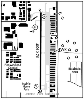
RWY 18–36: H4001X75 (CONC) S–30 MIRL
RWY 18: VASI(V4L)–GA 3.0° TCH 26′. Trees.
RWY 36: REIL. VASI(V4L)–GA 4.0° TCH 37′. Road. Rgt tfc.
SERVICE: S4 FUEL 100LL, JET A OX 1, 2 LGT MIRL Rwy 18–36 preset low intst; to incr intst and ACTVT REIL Rwy 36 aft ATCT clsd–CTAF.
AIRPORT REMARKS: Attended Mar–Oct Mon–Sat 1300–0200Z‡, Nov–Feb Mon–Sat 1400–0000Z‡, Sun 1400–0000Z‡. Extsv hel tfc west side of arpt. TPA–1400 (812) fixed wing, 1200 (612) rotary wing. West grass for rotary wing use only.
AIRPORT MANAGER: (972) 237-7591
WEATHER DATA SOURCES: AWOS–3P 118.475 (972) 606–1433.
COMMUNICATIONS: CTAF 128.55 UNICOM 123.075
®REGIONAL APP/DEP CON 135.975
TOWER 128.55 (1200–0200Z dalgt time; 1400–0000Z standard time) GND CON 121.15
CLEARANCE DELIVERY PHONE: For CD when ATCT is clsd ctc Regional Apch at 972-615-2799.
AIRSPACE:CLASSD svc 1300–0300Z‡ dalgt time, 1400–0000Z‡ standard time; other times CLASS G.
RADIO AIDS TO NAVIGATION: NOTAM FILE FTW.
MAVERICK (VH) (H) VORW/DME 113.1 TTT Chan 78 N32°52.15′ W97°02.43′ 176° 10.2 NM to fld. 536/6E. All acft arriving DFW are requested to turn DME off until departure due to traffic overload of Maverick DME
DME unusable:
180°–190° byd 10 NM
240°–260° byd 20 NM blo 3,500′
VOR unusable:
105°–110° byd 40 NM
• • • • • • • • • • • • • • • • • •
HELIPAD H1: H50X50 (CONC) PERIMETER LGTS