ARLINGTON MUNI (GKY)(KGKY) 4 S UTC–6(–5DT) N32°39.83′ W97°05.66′
628 B NOTAM FILE GKY
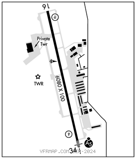
RWY 16–34: H6080X100 (CONC) S–60 MIRL 0.5% up NW
RWY 16: REIL. PAPI(P4L)–GA 3.0° TCH 42′.
RWY 34: MALSR. PAPI(P4L)–GA 3.0° TCH 55′.
SERVICE: S4 FUEL 100LL, JET A OX 4 LGT MIRL Rwy 16–34 preset med intst; higher intst by ATCT req. When ATCT clsd ACTVT MALSR Rwy 34–CTAF.
AIRPORT REMARKS: Attended continuously. 100LL self serve fuel. Extsv hel tfc west of rwy.
AIRPORT MANAGER: 817-459-5571
WEATHER DATA SOURCES: ASOS 127.375 (817) 557–0251.
COMMUNICATIONS: CTAF 128.625
®REGIONAL APP/DEP CON 118.1 124.3 125.2 125.8 135.975 (North) 125.8 135.975 (South) 118.1 125.8
TOWER 128.625 (1300–0300Z‡) GND CON/CLNC DEL 121.875
CLNC DEL 118.85 (RGNL APP CON when twr clsd)
AIRSPACE: CLASS D svc 1300–0300Z‡; other times CLASS G.
RADIO AIDS TO NAVIGATION: NOTAM FILE FTW.
MAVERICK (VH) (H) VORW/DME 113.1 TTT Chan 78 N32°52.15′ W97°02.43′ 186° 12.6 NM to fld. 536/6E. All acft arriving DFW are requested to turn DME off until departure due to traffic overload of Maverick DME
DME unusable:
180°–190° byd 10 NM
240°–260° byd 20 NM blo 3,500′
VOR unusable:
105°–110° byd 40 NM
ILS/DME 111.55 I–GKY Chan 52(Y) Rwy 34. Class IE. LOC unusable byd 15° right of course. Unmonitored when ATCT clsd.