FORT WORTH MEACHAM INTL (FTW)(KFTW) 5 N UTC–6(–5DT) N32°49.19′ W97°21.75′
710 B TPA–See Remarks ARFF Index–See Remarks NOTAM FILE FTW
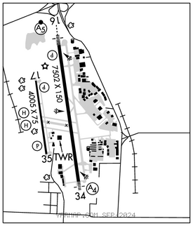
RWY 16–34: H7502X150 (CONC–GRVD) S–80, D–100, 2S–127, 2D–190, 2D/2D2–350 PCN 30 R/C/W/U HIRL 0.5% up N
RWY 16: MALSR. PAPI(P4R)–GA 3.0° TCH 59′. RVR–T Pole.
RWY 34: MALS. RVR–R Rgt tfc.
RWY 17–35: H4005X75 (ASPH) S–12.5, D–50 PCN 11 F/C/X/U MIRL
RWY 17: PAPI(P2L)–GA 3.75° TCH 56′. Berm. Rgt tfc.
RWY 35: PAPI(P2L)–GA 3.25° TCH 43′.
RUNWAY DECLARED DISTANCE INFORMATION
RWY 16: TORA–7502 TODA–7502 ASDA–7502 LDA–7502
RWY 34: TORA–7502 TODA–7502 ASDA–7455 LDA–7455
SERVICE: S4 FUEL 100LL, JET A, A1+ OX1, 3 LGT Rwy 17–35 LED lgt can appr brgtr than Rwy 16–34; ensure cor rwy alnmt.
AIRPORT REMARKS: Attended continuously. Birds on and invof arpt. Rwy 09–27 CLOSED indef. Class IV, ARFF Index A. ARFF Index B avbl all users with PPR. Helo skidding opns prohibited on Rwy 17–35. If skidding is rqrd, coord with ATCT to use Twy B. Rwy 17–35 Twys B, B1, C and D west of Rwy 16–34, Twy M east of Twy A, H, J, Txl G SE of Txl N clsd to acft with more than 30 psgr seats. Rwy 17–35 designed for acft with wingspan of 49 ft or less. Twys B and B1 designed for acft with wingspan less than 79 ft. Rwy 16–34 and Twys A, A1, and M designed for acft with wingspan less than 171 ft. All other Twys designed for acft with wingspan of less than 118 ft. Mkd US CUST pkrg southeast of Txl G and Txl N intxn. PPR for acr opns with more than 30 psgr seats–24 hr notice rqrd–call Arpt Ops 817–994–0653. TPA–Rwy 17–35 R/W 1300(590) AGL, F/W 1500(790) AGL, Rwy 16–34 1500(790) AGL, Jets 2000(1290) AGL. Arpt fees for use of cust svcs will be could imt upon ldg by city of Fort Worth Arpt opns psnl. User fee arpt. NOTE: See Special Notices–Arrival Alert.
AIRPORT MANAGER: 817 392-5400
WEATHER DATA SOURCES: ASOS (817) 740–3346
COMMUNICATIONS: ATIS 120.7
RCO 122.6 (FORT WORTH RADIO)
®RGNL APP/DEP CON 118.1 124.3 125.2 125.8 125.9 135.975 (North) 118.1 125.8 135.975 (South) 124.3 125.2 125.8
MEACHAM TOWER 118.3 GND CON 121.9 CLNC DEL 124.65
AIRSPACE: CLASS D.
VOR TEST FACILITY (VOT) 108.2
RADIO AIDS TO NAVIGATION: NOTAM FILE FTW.
RANGER (VH) (H) VORTACW 115.7 FUZ Chan 104 N32°53.37′ W97°10.77′ 240° 10.1 NM to fld. 639/6E.
VOR unusable:
275°–290° byd 40 NM
317°–327° byd 40 NM
MUFIN NDB (LOMW) 365 FT N32°53.59′ W97°22.40′ 165° 4.4 NM to fld. 744/8E.
ILS/DME 109.9 I–FTW Chan 36 Rwy 16. Class IT. LOM MUFIN NDB. DME also serves Rwy 34.
ILS/DME 109.9 I–UXT Chan 36 Rwy 34. Class IB. DME also serves Rwy 16. • • • • • • • • • • • • • • • • • •
HELIPAD H1: H35X35 (CONC)
HELIPAD H2: H35X35 (CONC)
HELIPORT REMARKS: H1 and H2 helipads are VMC dalgt use only; non–movement area. Hels repositioning byd imt prkg apron and under their own pwr must ctc ATC.