FORT SCOTT MUNI (FSK)(KFSK) 4 SW UTC–6(–5DT) N37°47.90′ W94°46.16′
918 B NOTAM FILE ICT
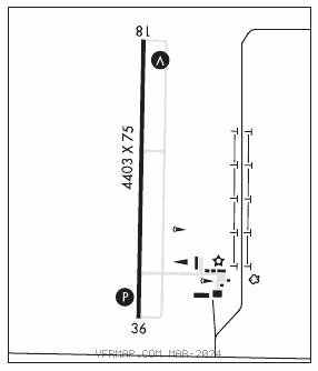
RWY 18–36: H4403X75 (ASPH) S–24 PCN 9 F/D/X/T MIRL 0.3% up S
RWY 18: REIL. VASI(V4L)–GA 3.0° TCH 33′. Tree.
RWY 36: REIL. PAPI(P2L)–GA 3.0° TCH 44′. Tree.
SERVICE: FUEL 100LL, JET A1+ LGT ACTIVATE MIRL Rwy 18–36, VASI Rwy 18, PAPI Rwy 36 and REIL Rwy 18 and Rwy 36–CTAF.
AIRPORT REMARKS: Attended Mon–Sat 1400–2300Z‡. Deer fence around airport perimeter. Ground drops rapidly 250′ from Rwy 18 end. NOTE: See Special Notices Section–Aerobatic Practice Areas.
AIRPORT MANAGER: 620-223-5490
WEATHER DATA SOURCES: AWOS–3P 124.425 (620) 215–5899.
COMMUNICATIONS: CTAF/UNICOM 122.8
®KANSAS CITY CENTER APP/DEP CON 125.55
CLEARANCE DELIVERY PHONE: For CD ctc Kansas City ARTCC at 913-254-8508.
RADIO AIDS TO NAVIGATION: NOTAM FILE COU.
BUTLER (VH) (H) VORTAC 115.9 BUM Chan 106 N38°16.32′ W94°29.30′ 198° 31.4 NM to fld. 8907E.
VOR unusable:
083°–093° byd 40 NM blo 13,500′
249°–259° byd 40 NM blo 18,000′
295°–305° byd 49 NM