FARMINGDALE
REPUBLIC (FRG)(KFRG) 1 E UTC–5(–4DT) N40°43.76′ W73°24.81′ 81 B TPA–See Remarks LRA ARFF Index–See Remarks NOTAM FILE FRG
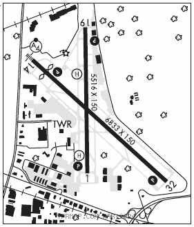
RWY 14–32: H6833X150 (ASPH–GRVD) S–45, D–60 PCN 51 F/B/X/T HIRL
RWY 14: MALSF. PAPI(P4L)–GA 3.0° TCH 50′. Thld dsplcd 676′. Pole.
RWY 32: REIL. PAPI(P4L)–GA 3.0° TCH 53′. Road. Rgt tfc.
RWY 01–19: H5516X150 (ASPH–GRVD) S–45, D–60 PCN 76 F/C/X/T MIRL 0.3% up N
RWY 01: REIL. PAPI(P4L)–GA 3.09° TCH 44′. Pole. Rgt tfc.
RWY 19: REIL. PAPI(P4L)–GA 3.1° TCH 43′. Bldg.
LAND AND HOLD–SHORT OPERATIONS
LDG RWY HOLD–SHORT POINT AVBL LDG DIST
RWY 32 01–19 3650
RUNWAY DECLARED DISTANCE INFORMATION
RWY 01: TORA–5516 TODA–5516 ASDA–5516 LDA–5116
RWY 14: TORA–6833 TODA–6833 ASDA–6833 LDA–6157
RWY 19: TORA–5516 TODA–5516 ASDA–5516 LDA–5516
RWY 32: TORA–6833 TODA–6833 ASDA–6833 LDA–6833
ARRESTING GEAR/SYSTEM
RWY 14: EMAS
RWY 32: EMAS
SERVICE: S4 FUEL 100LL, JET A OX 1, 2, 3, 4 LGT When ATCT clsd actvt REIL Rwys 01, 19, 32; PAPI Rwys 01, 19, 14, and 32; HIRL Rwy 14–32; MIRL Rwy 01–19; twy lgts–CTAF. Rwy 19 PAPI unusbl byd 4 deg left of cntrln.
NOISE: Voluntary NS ABTMT procedures in effect for fixed wing and helicopter. Ctc arpt management 631–752–7707 extension 6108.
AIRPORT REMARKS: Attended continuously. Birds invof arpt. Class IV ARFF Index A. Index B avbl on request call 631–752–7707. Acft with wingspan 79′ or larger are adzd to taxi or back–taxi on rwys. Twys may not provide adequate width, turning radius, and or separation from obstructions. Wooded area south of Twy A, east of Twy G clsd to helicopters. Jet maint runups pmtd only in the Twy A, D, F, & G holding bays. TPA–1180(1100) reciprocating eng, 1680(1600) Turboprop/Jet. Acft parking for US Cstms is located on the main terminal ramp. All international arrivals must ctc FBO for svc when clearing cstms. All international arrivals must not enter the main terminal ramp until FBO personnel are present for marshalling. Ctc arpt ops 122.9 mHz for instructions. Terminal use fees apply. Ldg fee for all acft exc mil and government.
AIRPORT MANAGER: 631-752-7707
WEATHER DATA SOURCES: ASOS (631) 752–8129 LAWRS.
COMMUNICATIONS: CTAF 118.8 ATIS 126.65 UNICOM 122.95
®NEW YORK APP CON 128.125
®NEW YORK DEP CON 125.7
TOWER 118.8 (1200–0400Z‡) GND CON 121.6 CLNC DEL 128.25 When FRG twr clsd
CLEARANCE DELIVERY PHONE: For CD when ATCT clsd ctc New York Apch on 128.25, if una call 516-683-2962.
AIRSPACE: CLASS D svc 1200–0400Z‡; other times CLASS G.
RADIO AIDS TO NAVIGATION: NOTAM FILE ISP.
DEER PARK (L) (L) VORW/DME 117.7 DPK Chan 124 N40°47.50′ W73°18.22′ 245° 6.3 NM to fld. 123/12W.
VOR/DME unusable:
Byd 25 NM blo 5,000′
DME unusable:
265°–274° byd 17 NM blo 5,000′
275°–280°
281°–015° byd 17 NM blo 5,000′
FRIKK NDB (LOMW) 407 FR N40°46.59′ W73°28.95′ 146° 4.2 NM to fld. 153/14W. NOTAM FILE FRG.
ILS 111.9 I–FRG Rwy 14. Class IE. LOM FRIKK NDB. Autopilot cpd apch na blw 550′ MSL. LOM NDB unmonitored.
• • • • • • • • • • • • • • • • • •
HELIPAD H1: H79X79 (ASPH)
HELIPAD H2: H44X44 (ASPH)
HELIPORT REMARKS: H1 lctd on Twy B at the intersection of Twy F. H2 located on Twy B north of Twy B6.