MEADOW LAKE (FLY)(KFLY) 14 NE UTC–7(–6DT) N38°56.57′ W104°34.19′
6878 B NOTAM FILE DEN
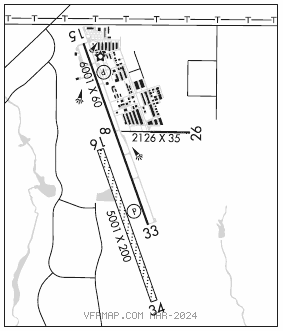
RWY 15–33: H6001X60 (ASPH) S–12.5 MIRL 1.4% up NW
RWY 15: REIL. PAPI(P2L)–GA 3.5° TCH 42′. Road.
RWY 33: REIL. PAPI(P2L)–GA 3.0° TCH 39′. Rgt tfc.
RWY 16–34: 5001X200 (TURF)
RWY 08–26: H2126X35 (ASPH–GRVL) 1.2% up W
RWY 08: Rgt tfc.
RWY 26: Road.
SERVICE: S4 FUEL 100LL OX2 LGT Actvt REIL Rwy 15 and 33; actvt and incr intst MIRL Rwy 15–33–CTAF. PAPI Rwy 15 and 33 on consly.
AIRPORT REMARKS: Attended 1500–0000Z‡. . Wildlife on and invof airport. Gliders operate on Rwy 16–34 and west side of arpt. 100LL avbl 24 hrs self svc credit card. Rwy 08–26 1149 ft grvl on E end of rwy, 925 ft asph on W end of rwy. Rwy 26; 4′ terrain 5′ from rwy edge first 100′ on both sides of rwyRwy 26 4′ fence 50′ right of centerline 95′ from thld. CTN: intensive USAF student training invof Colorado Springs and Pueblo Colorado. Rwy 26 15′ road extends east from thld. CTN: powered paragliders and mobile aerostats oper southeast side of arpt sfc–500′. Rwy 16–34 has edges and thlds marked with white tires. Rwy 08–26 edge marked with white reflectors and tires. See Special Notices–USAF 306 FTG Flight Training Areas, Vicinity of Colorado Springs and Pueblo Colorado.
AIRPORT MANAGER: 719-339-0928
WEATHER DATA SOURCES: AWOS–3PT 118.450 (719) 683–5371.
COMMUNICATIONS: CTAF/UNICOM 122.7
®SPRINGS APP/DEP CON 124.0
CLEARANCE DELIVERY PHONE: For CD ctc Colorado Springs Apch at 719-556-9105.
RADIO AIDS TO NAVIGATION: NOTAM FILE DEN.
BLACK FOREST (VH) (DH) VORW/DME 112.5 BRK Chan 72 N38°56.67′ W104°38.01′ 084° 3.0 NM to fld. 6935/8E.
VOR unusable:
046°–109° byd 40NM
110°–120° byd 40 NM blo 9,000′
110°–120° byd 50 NM
121°–132° byd 40 NM
133°–149° byd 40 NM blo 7,000′
133°–149° byd 50 NM blo 8,500′
133°–149° byd 54 NM
150°–165° byd 40 NM
180°–187° byd 40 NM blo 7,400′
180°–187° byd 46 NM
188°–197° byd 40 NM
198°–208° byd 40 NM blo 16,300′
198°–208° byd 48 NM
209°–272° byd 40 NM
273°–283° byd 40 NM blo 15,000′
273°–283° byd 60 NM
284°–359° byd 40 NM
305°–045° byd 10 NM blo 13,000′
305°–045° byd 26 NM
DME unusable:
210°–230° byd 30 NM blo 17,000′
230°–250° byd 30 NM blo 17,900′
250°–267° byd 30 NM blo 17,000′
305°–045° byd 27 NM blo 13,000′
330°–045° byd 20 NM blo 10,500′