FITCHBURG MUNI (FIT)(KFIT) 3 SE UTC–5(–4DT) N42°33.23′ W71°45.55′
345 B TPA–1347(1002) NOTAM FILE FIT
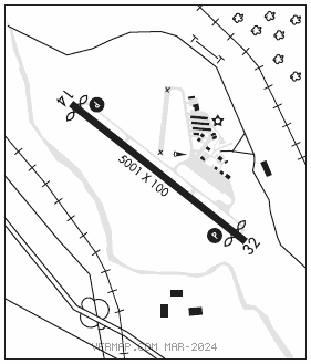
RWY 14–32: H5001X100 (ASPH) S–30, D–41 MIRL 0.3% up NW
RWY 14: REIL. PAPI(P4L)–GA 3.0° TCH 40′. Thld dsplcd 163′. Trees.
RWY 32: REIL. PAPI(P4L)–GA 3.5° TCH 46′. Thld dsplcd 300′. Trees.
RUNWAY DECLARED DISTANCE INFORMATION
RWY 14: TORA–5001 TODA–5001 ASDA–4701 LDA–4538
RWY 32: TORA–5001 TODA–5001 ASDA–4838 LDA–4538
SERVICE: S4 FUEL 100LL, JET A, A+ LGT Actvt REIL Rwy 14 and 32; PAPI Rwy 14 and 32; MIRL Rwy 14–32–123.0. Rotg bcn not avbl during dalgt IFR conds. Rwy 14 PAPI unusbl byd 5 degs L and R of cntrln.
AIRPORTREMARKS: Attended 1300–2200Z‡. Wildlife on and invof arpt. Ldg fee for corporate and commercial flts only. Cold temperature airport. Altitude correction required at or below –22C.
AIRPORT MANAGER: 978-345-9580
WEATHER DATA SOURCES: ASOS 135.175 (978) 343–9121.
COMMUNICATIONS: CTAF/UNICOM 122.7
RCO 122.15 (BRIDGEPORT RADIO)
®BOSTON APP/DEP CON 124.4
CLEARANCE DELIVERY PHONE: For CD ctc Boston Apch at 603-594-5552.
RADIO AIDS TO NAVIGATION: NOTAM FILE BDR.
GARDNER (L) (L) VOR/DME 116.95 GDM Chan 116(Y) N42°32.76′ W72°03.49′ 102° 13.3 NM to fld. 128014W.