FRESNO
FRESNO CHANDLER EXEC (FCH)(KFCH) 2 W UTC–8(–7DT) N36°43.93′ W119°49.22′ 280 B TPA–See Remarks NOTAM FILE FCH
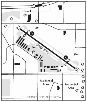
RWY 12–30: H3627X75 (ASPH) S–17 MIRL
RWY12: REIL. PAPI(P2L)–GA 3.0° TCH 40′. Thld dsplcd 415′. Road. Rgt tfc.
RWY30: REIL. PAPI(P4R)–GA 3.0° TCH 40′. Thld dsplcd 538′. Road.
SERVICE: S2 FUEL 100LL LGT ACTIVATE REIL Rwy 12 and Rwy 30; PAPI Rwy 12 and 30; MIRL Rwy 12–30 and twy lgts–CTAF btn SS–SR.
NOISE: Practice ldgs and low apchs and touch and go ldg or stop–and–go ops authorized only between 1500–0600Z‡. Rwy 12 practice ldgs and low apchs and touch and go ldg or stop–and–go ops not permitted due to noise sensitive residential areas southeast of arpt. After tkf climb on rwy heading until passing 800′ MSL, for safety and noise abatement initial climb out at best rate–of–climb recommended.
AIRPORT REMARKS: Attended 1600–0100Z‡. 100LL fuel avbl 24 hrs. Numerous birds invof arpt. Rwy 30 calm wind rwy when wind reported by AWOS less than 5 kts. TPA–VFR Heliport 800(520), VFR 1300(1020).
AIRPORT MANAGER: (559) 621-4508
WEATHER DATA SOURCES: AWOS–3 135.225 (559) 488–1040.
COMMUNICATIONS: CTAF/UNICOM 123.0
®APP CON 119.0 119.6
®DEP CON 119.0
CLNC DEL 119.0
CLEARANCE DELIVERY PHONE: For CD ctc Fresno Apch at 559-454-9828.
RADIO AIDS TO NAVIGATION: NOTAM FILE RIU.
FRIANT (L) (L) VORTACW 115.6 FRA Chan 103 N37°06.27′ W119°35.73′ 189° 24.8 NM to fld. 238017E.