LUCE CO (ERY)(KERY) 3 SE UTC–5(–4DT) N46°18.66′ W85°27.43′
869 B NOTAM FILE ERY
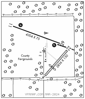
RWY 11–29: H4304X75 (ASPH) S–8 MIRL 0.4% up W
RWY 11: REIL. PAPI(P4L)—GA 3.2° TCH 41′.
RWY 29: REIL. PAPI(P4L)—GA 3.2° TCH 41′.
RWY 04–22: 2856X150 (TURF)
RWY 04: Thld dsplcd 936′. Fence.
RWY 22: Trees.
SERVICE: FUEL 100LL, JET A+ LGT Actvt wind cone; REIL Rwy 11 and 29; PAPI Rwy 11 and 29; MIRL Rwy 11–29—CTAF.
AIRPORTREMARKS: Attended Mon–Fri 1300–2100Z‡, Sat and Sun on call. Wkends O/R. Deer, birds, and wildlife on and invof arpt. Rwy 04–22 clsd when snow covd exc for ski equipped acft. Rwy 04 mkg type: 3 ft yellow cones. Rwy 22 mkg type: 3 ft yellow cones.
AIRPORT MANAGER: 906-291-0214
WEATHER DATA SOURCES: AWOS–3P 119.525 (906) 293–2979.
COMMUNICATIONS: CTAF/UNICOM 122.8
NEWBERRY RCO 122.4 (GREEN BAY RADIO)
®MINNEAPOLIS CENTER APP/DEP CON 134.6
CLEARANCE DELIVERY PHONE: For CD if una to ctc on FSS freq, ctc Minneapolis ARTCC at 651-463-5588.
RADIO AIDS TO NAVIGATION: NOTAM FILE ISQ.
SCHOOLCRAFT COUNTY (DH) DME 114.85 ISQ Chan 95(Y) N45°58.58′ W86°10.41′ 056° 36.0 NM to fld. 680.
DME unusable:
Blw 7,000′