EL DORADO
EL DORADO/CAPT JACK THOMAS MEML (EQA)(KEQA) 3 SE UTC–6(–5DT) N37°46.45′ W96°49.06′ 1379 B NOTAM FILE ICT
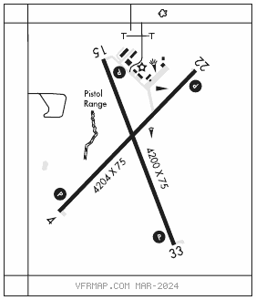
RWY 04–22: H4204X75 (ASPH) S–18, D–23 HIRL
RWY 04: PAPI(P2L)–GA 3.0° TCH 40′.
RWY 22: PAPI(P2L)–GA 3.0° TCH 40′.
RWY 15–33: H4200X75 (CONC) S–12.5, D–12.5 HIRL
RWY 15: PAPI(P2L)–GA 3.0° TCH 40′. Trees.
RWY 33: PAPI(P2L)–GA 3.0° TCH 40′.
SERVICE: FUEL 100LL, JET A, MOGAS LGT ACTVT PAPI Rwy 04 and 22, 15 and 33; HIRL Rwy 04–22 and 15–33–CTAF.
AIRPORT REMARKS: Attended Mon–Fri 1300–2100Z‡. Aft hrs phone nmbr posted at arpt. Fuel: self serve 100LL, Jet A, MOGAS (auto gas 91 octane). Avoid flt over prison north of arpt. Aft hrs phone nmbr posted at arpt. Courtesy car, pilot lounge with computer, WIFI, telephone, restrooms key code CTAF freq. Arpt address 1485 S. E. 30th.
AIRPORT MANAGER: 316-321-1327
WEATHER DATA SOURCES: AWOS–3P 120.875 (316) 322–8095.
COMMUNICATIONS: CTAF/UNICOM 122.8
®WICHITA APP/DEP CON 134.8
CLEARANCE DELIVERY PHONE: For CD ctc Wichita Apch at 316-350-1520.
RADIO AIDS TO NAVIGATION: NOTAM FILE ICT.
WICHITA (H) (H) VORTACW 113.8 ICT Chan 85 N37°44.72′ W97°35.03′ 080° 36.5 NM to fld. 1472/7E.
TACAN AZIMUTH unusable:
025°–035° blo 4,000′
040°–055° byd 20 NM
147°–159° blo 4,900′
VOR unusable:
025°–035° blo 4,000′
147°–159° blo 4,400′