ERIE MUNI (EIK)(KEIK) 3 S UTC–7(–6DT) N40°00.62′ W105°02.89′
5119 B NOTAM FILE DEN
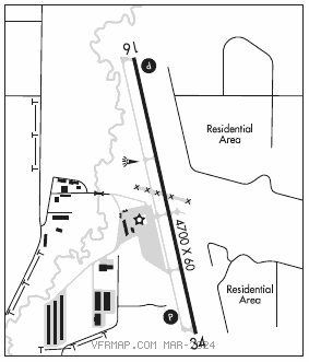
RWY 16–34: H4700X60 (CONC) S–12.5 MIRL
RWY 16: REIL. PAPI(P2L)–GA 3.0° TCH 58′. Rgt tfc.
RWY 34: PAPI(P2L)–GA 3.0° TCH 52′. Tree.
SERVICE: S4 FUEL 100LL, JET A OX 3, 4 LGT ACTVT REIL Rwy 16; PAPI Rwy 16 and 34; MIRL Rwy 16–34–CTAF.
AIRPORT REMARKS: Attended Mon–Sat 1500–0000Z‡, Sun 1500–2100Z‡. Aft hr emerg–303–870–5659. Fuel: 100LL: Self svc avbl H24 with credit card. Twy A lgtd. Rwy 16–34 –2 ft trrn 60–70 ft E of cntrln full len. Rwy 16 has –2 to –6 ft ditch wi 700 ft of rwy end various locations. Rwy 34 30 ft road 1350 ft fm thr both sides; –6 to –12 ft ditch 60 ft L of cntrln parl to first 750 ft of rwy.
AIRPORT MANAGER: 303-664-0633
WEATHER DATA SOURCES: AWOS–3PT 133.825 (303) 604–4339.
COMMUNICATIONS: CTAF/UNICOM 123.0
®DENVER APP/DEP CON 125.12
CLEARANCE DELIVERY PHONE: For CD ctc Denver Apch at 303-342-1916.
RADIO AIDS TO NAVIGATION: NOTAM FILE BJC.
JEFFCO (VH) (DH) VORW/DME 115.4 BJC Chan 101 N39°54.78′ W105°08.34′ 025° 7.2 NM to fld. 5737/11E.
VOR unusable:
180°–225° byd 40 NM
226°–245° byd 36 NM blo 17,000′
246°–278° byd 30 NM blo 19,000′
279°–300° byd 34 NM blo 18,000′
301°–335° byd 40 NM
DME unusable:
246°–278° byd 30 NM