EAGLE CO RGNL (EGE)(KEGE) P (ARNG) 4 W UTC–7(–6DT) N39°38.57′ W106°54.96′
6547 B Class I, ARFF Index C NOTAM FILE EGE
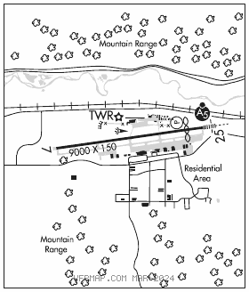
RWY 07–25: H9000X150 (ASPH–GRVD) S–75, D–140, 2S–175, 2D–255 PCN 45 F/B/X/U HIRL
RWY 07: REIL. Tree. Rgt tfc. 0.9% up.
RWY 25: MALSR. PAPI(P4R)–GA 3.0° TCH 55′. Thld dsplcd 1000′. 1.0% down.
RUNWAY DECLARED DISTANCE INFORMATION
RWY 07: TORA–9000 TODA–9000 ASDA–9000 LDA–9000
RWY 25: TORA–9000 TODA–9000 ASDA–9000 LDA–8000
SERVICE: S4 FUEL 100LL, JET A1, A1+, MOGAS OX1, 3 LGT When ATCT CLOSED ACTVT MALSR RWY 25; REIL RWY 07; HIRL RWY 07–25–CTAF. PAPI RWY 25 OPR consly. MILITARY– FUEL A+ (1300–0400Z‡, C970–524–7700, OT $125 per hr.) (NC–100LL, A1, A1+) FLUID HPOX–RB
AIRPORT REMARKS: Attended Apr–Nov 1400–0200Z‡, Dec–Mar 1400–0600Z‡. Unscheduled air carrier operations with more than 30 passenger seats call arpt fire department 970–328–2688. High unmarked terrain all quadrants. Ngt ops discouraged to pilots unfamiliar with arpt. Mountain top 10:1 clnc 13000′ from thld, 1500′ left of rwy centerline extended. Critical acft are Category D IV, B757–200 equivalent and lower. Recommend all acft departing Rwy 25 initiate a left turn as soon as alt and safety permit to avoid high terrain. Extensive military helicopter training ops sfc to 1000′ AGL within 25 NM radius Eagle Co Arpt 1330–0500Z‡. No snow removal or rwy monitoring Nov–Apr 0600–1300Z‡. Acrs should not lve or enter Twy A fm ramp east of Twy C–2. Cold temperature airport. Altitude correction required at or below –20C. For twr hrs ctc ARFF at 970–328–2688. U.S. Customs user fee arpt: regular office hrs Thu–Mon 1600–0000Z‡. After hrs svc avbl. Office 970–524–0490. After hrs 303–472–1125. Three hr advance notice required. Ldg fee. Ldg fee of $2.99 per thousand lbs for GA acft greater than 12,000 lbs.
AIRPORT MANAGER: (970) 328-2680
WEATHER DATA SOURCES: AWOS–3PT 135.575 (970) 524–7386.
COMMUNICATIONS: CTAF 119.8 ATIS 135.575
RCO 122.2 (DENVER RADIO)
®DENVER CENTER APP/DEP CON 128.65
TOWER 119.8 (1400–0200Z‡ hrs.) GND CON 121.8 CLNC DEL 124.75
CLEARANCE DELIVERY PHONE: For CD ctc eagle ATCT at 970-524-0803, when ATCT clsd ctc Denver ARTCC at 303-651-4257.
AIRSPACE: CLASS D svc 1400–0200Z‡; other times CLASS E.
RADIO AIDS TO NAVIGATION: NOTAM FILE DEN.
SNOW (L) (L) VORW/DME 109.2 SXW Chan 29 N39°37.77′ W106°59.47′ 065° 3.6 NM to fld. 807012E. VOR/DME unmonitored 0600–1300Z‡.
VOR portion unusable:
310°–355°
VOR/DME unusable:
115°–135°
ILS/DME 109.75 I–ESJ Chan 34(Y) Rwy 25. Class IA. LOC unusable byd 30° right of course. DME unusable byd 30° right of course; byd 30° left of centerline.
LDA/DME 108.3 I–VAZ Chan 20 Rwy 25X. LOC unusable byd 14 NM blo 10,940′; byd 15° left and right of course.