ELLINGTON (EFD)(KEFD) P (ANG CG NASA ARNG) 15 SE UTC–6(–5DT) N29°36.44′
W95°09.53′ 33 B TPA—See Remarks LRA Class IV, ARFF Index A NOTAM FILE EFD
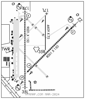
RWY 17R–35L: H9001X150 (CONC–GRVD) S–100, D–190, 2S–175, 2D–590, 2D/2D2–800 PCN 120R/B/W/T HIRL CL
RWY 17R: MALSF. TDZL. PAPI(P4L)—GA 3.0° TCH 48′. RVR–TR
RWY 35L: MALSF. TDZL. PAPI(P4L)—GA 3.0° TCH 32′. RVR–TR Rgt tfc.
RWY 04–22: H8001X150 (CONC–GRVD) S–100, D–164, 2S–175, 2D–300, 2D/2D2–668 PCN 110R/B/W/T HIRL CL
RWY 04: PAPI(P4L)—GA 3.0° TCH 50′. RVR–TR Rgt tfc.
RWY 22: MALSR. TDZL. PAPI(P4L)—GA 3.0° TCH 50′. RVR–TR
RWY 17L–35R: H4609X75 (CONC) S–24, D–63, 2S–80, 2D–145, 2D/2D2–300 PCN 12 R/C/W/T
RWY 35R: Rgt tfc.
RUNWAY DECLARED DISTANCE INFORMATION
RWY 04: TORA–8001 TODA–8001 ASDA–8001 LDA–8001
RWY 17L:TORA–4609 TODA–4609 ASDA–4609 LDA–4609
RWY 17R:TORA–9001 TODA–9001 ASDA–9001 LDA–9001
RWY 22: TORA–8001 TODA–8001 ASDA–8001 LDA–8001
RWY 35L:TORA–9001 TODA–9001 ASDA–9001 LDA–9001
RWY 35R:TORA–4609 TODA–4609 ASDA–4609 LDA–4609
ARRESTING GEAR/SYSTEM
RWY 17R BAK–14 BAK–12B(B) (1500'). BAK–14 BAK–12B(B) (1850'). RWY 35L
RWY 04 BAK–14 BAK–12B(B) (1563'). BAK–14 BAK–12B(B) (1496'). RWY 22
SERVICE: S4 FUEL 100LL, JET A OX 2, 4 MILITARY— A–GEAR Potential for tail hook skip on Rwy 17R–35L and Rwy 04–22 due to centerline lgt within 200′ of Rwy A–G. A–Gear lgtd mrk placement exceeds 75′ from rwy edge. JASU 1(–95) 1(–86) 1(JETEX5) FUEL A++(Mil), A, A+, J8 (C281–484–6551.) (NC–100LL) FLUID LHOX HPOX
NOISE: NS ABTMT: Noise sensitive areas S and E of fld. Jet acft rstd to str–in full stop ldg only btn 0400–1300Z‡ dly, 0400–1900Z‡ Sun. On dep jet acft min use of after burners and climb rwy hdg to 1000′ prior to turns or rejoin.
AIRPORT REMARKS: Attended continuously. Caution:nmrs small acft with extv trng in area of arpt. Nmrs birds on and invof arpt all quadrants. Be alert for mil acft at 1600′ MSL making overhead apchs. Arpt clsd to acft with wingspan 171′ or greater exc 24 hrs PPR 281–433–1612. 70′ AGL tanks lctd 1400′ northeast of Rwy 17R apch. Street lgts lctd 700′ east of Rwy 17R apch may be mistaken for apch lgts. TPA—VFR rectangular 1100(1067), overhead 1600(1567), lgt acft 600(567). Twy B unlgtd east of Rwy 17R–35L, dalgt use only. Rwy 17L–35R btn Twy C and Twy G dual purpose rwy/twy with twy lgts. Parking ramp capacity TDT–710. Rwy 17R arresting barriers 1500′ lctd in safety area 14" lip each side of rwy. Rwy 35L arresting barriers 1849′ lctd in safety area 14" lip each side of rwy. Rwy 04 arresting barriers 1563′ lctd in safety area 14" lip each side of rwy. Rwy 22 arresting barriers 1496′ lctd in safety area 14" lip each side of rwy. PPR for unscheduled air carrier ops, ctc 281–433–1612. Rwy 17L–35R and Twy B east of Rwy 17R–35L not avble for air carrier acft. NSTD afld mrk on ANG acft prk apn. Space Launch Activity Area—See Special Notices.
MILITARY REMARKS: See FLIP AP/1 Supplementary Arpt Remarks. UAS ops within Ellington Class D airspace, opr hrs vary.
ANG ANG ramp clsd to all acft exc Official Business only. 24 hrs PPR, ctc Base OPS 1200–2130Z‡ Tue–Fri, clsd wkend & hol. DSN 454–2142, C281–929–2142. Comd Post avbl 24 hr DSN 454–2716, C281–929–2716. All other tran acft ctc FBO 281–484–6551. BASH PHASE II cond Jun–Sep for migratory birds. BASH PHASE I Oct–May. CG Minimum 24 hr PPR exc CG msn, C713–578–3000.
AIRPORT MANAGER: 713-847-4200
WEATHER DATA SOURCES: AWOS–3 135.575 (713) 847–4430.
COMMUNICATIONS: ATIS 135.575 269.9 (713) 847–4430 UNICOM 122.95
®HOUSTON APP/DEP CON 134.45 284.0
TOWER 126.05 253.5 GND CON 121.6 275.8
ARNG OPS 41.00 (1230–2200Z‡ Mon–Fri, prior req only) 142.2 Call Texan ops.
LONE STAR COMD POST 142.2 ANG OPS COMD POST 288.5
AIRSPACE: CLASS D.
RADIO AIDS TO NAVIGATION: NOTAM FILE CXO.
TRINITY (VL) (DL) VORW/DME 114.75 MHF Chan 94(Y) N29°32.78′ W94°44.85′ 273° 21.8 NM to fld. 38/7E.
VOR unusable:
060°–079° byd 40 NM
080°–090° byd 40 NM blo 6,000′
080°–090° byd 50 NM blo 8,000′
091°–109° byd 40 NM
110°–190° blo 2,000′
(L) TACAN Chan 31 EFD (109.4) N29°36.36′ W95°09.58′ at fld. 29/5E. NOTAM FILE EFD.
DME unusable:
065°–090° byd 30 NM
TACAN AZIMUTH unusable:
065°–090° byd 30 NM
ILS 110.3 I–LPV Rwy 17R. Class IE.
ILS 110.1 I–FNF Rwy 22. Class IE.
ILS 111.1 I–EFD Rwy 35L. Class IT.