AUSTIN EXEC (EDC)(KEDC) 12 NE UTC–6(–5DT) N30°23.85′ W97°33.98′
620 B NOTAM FILE EDC
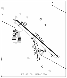
RWY 13–31: H6025X100 (ASPH) D–101 MIRL 0.4% up NW
RWY 13: REIL. PAPI(P4L)—GA 3.0° TCH 40′. Thld dsplcd 600′. Tree.
RWY 31: REIL. PAPI(P4L)—GA 3.0° TCH 40′.
RWY 16–34: H1550X25 (ASPH) S–8 1.0% up N
SERVICE: S4 FUEL 100LL, JET A LGT ACTVT REIL Rwys 13 and 31; MIRL Rwy 13–31—CTAF. PAPI Rwys 13 and 31 opr consly.
AIRPORT REMARKS: Attended continuously. Rwy 16–34 CLOSED indefly. Rwy 16–34 extsv cracking, vegetation growing through. NW end of Rwy 13–31 and Twy A has a 16′ drop off at end of pavement. Rwy 13–31 twy edges are mkd by reflector posts.
AIRPORT MANAGER: 512-247-7678
WEATHER DATA SOURCES: AWOS–3 118.825 (512) 616–2967.
COMMUNICATIONS: CTAF 120.3 UNICOM 122.975
®AUSTIN APP/DEP CON 127.225
EXECUTIVE TOWER 120.3 (1200–0400Z‡)
GND CON 119.45 CLNC DEL 126.025 (Aus App/Dep when EDC twr clsd)
CLEARANCE DELIVERY PHONE: For CD ctc Austin Apch at 512-369-7865.
AIRSPACE: CLASS D svc 1200–0400Z‡; other times CLASS E.
RADIO AIDS TO NAVIGATION: NOTAM FILE AUS.
CENTEX (VH) (H) VORTACW 112.8 CWK Chan 75 N30°22.71′ W97°31.79′ 295° 2.2 NM to fld. 593/6E.
VOR unusable:
180°–190° byd 40 NM
200°–210° byd 40 NM
COMM/NAV/WEATHER REMARKS: VFR deps requesting ATC svc remain clear of the final apch crs of Rwys 17L and 17R. If the acft is initially eastbound, ctc AUS Apch Ctl on 127.22. If the acft is initially westbound ctc AUS Apch Ctl on 125.32. AUS Clearance Delivery 126.025.