DAVID WAYNE HOOKS MEML (DWH)(KDWH) 17 NW UTC–6(–5DT) N30°03.71′
W95°33.17′ 152 B NOTAM FILE DWH
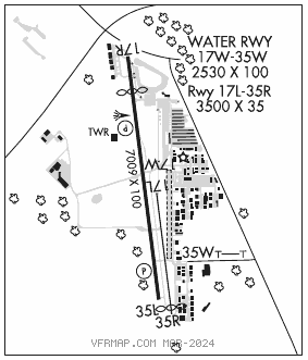
RWY 17R–35L: H7009X100 (ASPH) S–30, D–85 HIRL
RWY 17R: REIL. PAPI(P4R)—GA 3.0° TCH 52′. Thld dsplcd 1007′. Road.
RWY 35L: REIL. PAPI(P4L)—GA 3.0° TCH 41′. Trees.
RWY 17L–35R: H3500X35 (ASPH) S–12.5
RWY 35R: Thld dsplcd 208′. Antenna. Rgt tfc.
RUNWAY DECLARED DISTANCE INFORMATION
RWY 17R:TORA–7009 TODA–7009 ASDA–7009 LDA–6002
RWY 35L:TORA–6700 TODA–6700 ASDA–6700 LDA–6700
SERVICE: S4 FUEL 100LL, JET A, A1+ OX 2 LGT When ATCT clsd actvt REIL Rwys 17R and 35L; HIRL Rwy 17R–35L—CTAF. 17R REIL lctd at dsplcd thld.
NOISE: Noise sensitive area SW of arpt. All mil acft departing Rwy 17R climb rwy hdg 650 ft MSL prior to turns or rejoin.
AIRPORT REMARKS: Attended continuously. Birds and deer on and invof arpt. Hel practice area west of ATCT at or blo 600 ft. Twys A and B clsd east of Rwy 17R indef. Acft 25000 lbs and ovr are rstrd to Twys C, P, E (btn Twys P and G), Twy G (north of Twy E), ramps A and C and the tomball jet cntr ramp. All other twys rstrd to acft below 25000 lbs. Twys D and K rstrd to acft 12500 lbs and blw. Twy K rstrd to piston acft only. Twys unlgtd. After SS large acft use Twy P btn Twys E and C. Intersection where Twys Papa, Echo, Juliette and Kilo meet is referred to as the triangle. Four hel prkg spots lctd east of Twy K.
AIRPORT MANAGER: 281-376-5436
WEATHER DATA SOURCES: ASOS (281) 251–7853
COMMUNICATIONS: CTAF 118.4 ATIS 128.375 UNICOM 122.95
®HOUSTON APP/DEP CON 119.7
HOOKS TOWER 118.4 (West) 127.4 (East) (1300–0400Z‡) GND CON 121.8 CLNC DEL 119.45
CLEARANCE DELIVERY PHONE: For CD when ATCT clsd, ctc Houston Apch on CD freq or call 281-443-5844. for IFR cancellation when ATCT clsd, call 281-443-5888.
AIRSPACE: CLASS D svc 1300–0400Z‡; other times CLASS G.
RADIO AIDS TO NAVIGATION: NOTAM FILE IAH.
HUMBLE (H) (H) VORTACW 116.6 IAH Chan 113 N29°57.42′ W95°20.74′ 295° 12.5 NM to fld. 81/5E. VORTAC monitored by ATCT
VOR portion unusable:
060°–070° byd 35 NM
175°–185° byd 20 NM blo 3,000′
Byd 30 NM blo 2,000′
DME unusable:
015°–090° byd 30 NM blo 2,000′
130°–320° byd 30 NM blo 2,000′
175°–185° byd 20 NM blo 3,000′
230°–250°
TACAN AZIMUTH unusable:
040°–055° blo 5,000′
150°–320° blo 4,500′
150°–320° byd 10 NM
LOC/DME 110.5 I–HEW Chan 42 Rwy 17R. DME unmonitored.
• • • • • • • • • • • • • • • • • •
WATERWAY 17W–35W: 2530X100 (WATER)
WATERWAY 17W: Berm.
WATERWAY 35W: Berm. Rgt tfc.
SEAPLANE REMARKS: Rwy 17W marked by buoy. Rwy 35W marked by buoy.