DENTON ENTERPRISE (DTO)(KDTO) 3 W UTC–6(–5DT) N33°12.12′ W97°11.95′
643 B TPA–1443(800) NOTAM FILE DTO
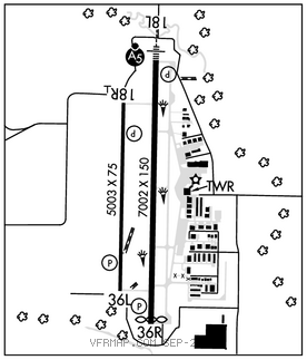
RWY 18L–36R: H7002X150 (ASPH) S–70, D–100 MIRL
RWY 18L: MALSR. PAPI(P4L)–GA 3.0° TCH 50′.
RWY 36R: PAPI(P4L)–GA 3.0° TCH 50′. Thld dsplcd 100′. Trees.
RWY 18R–36L: H5003X75 (ASPH) S–30 MIRL 0.3% up N
RWY 18R: PAPI(P4L)–GA 3.0° TCH 42′.
RWY 36L: PAPI(P4L)–GA 3.0° TCH 42′.
RUNWAY DECLARED DISTANCE INFORMATION
RWY 18L:TORA–7002 TODA–7002 ASDA–6502 LDA–6502
RWY 36R:TORA–7002 TODA–7002 ASDA–6602 LDA–6502
SERVICE: S4 FUEL 100LL, JET A LGT Dusk–dawn when ATCT clsd, MIRL Rwy 18L–36R and 18R–38L preset to low intst; to incr intst and ACTVT MALSR Rwy 18–CTAF.
AIRPORTREMARKS:Attended 1200–0400Z‡. Arpt closed to ultralights and gliders. Mowing opns on arpt May–Sept. Rwy 18L designated as a calm wind rwy.
AIRPORT MANAGER: 940-349-7736
WEATHER DATA SOURCES: ASOS 119.325 (940) 383–8457.
COMMUNICATIONS: CTAF 119.95 ATIS 119.325 UNICOM 122.95
®REGIONAL APP/DEP CON 118.1
TOWER 119.95 (1200–0400z‡) GND CON 123.95 CLNC DEL 123.95
CLEARANCE DELIVERY PHONE: For CD when ATCT is clsd ctc Regional Apch at 972-615-2799.
AIRSPACE: CLASS D svc 1200–0400Z‡; other times CLASS G.
RADIO AIDS TO NAVIGATION: NOTAM FILE FTW.
RANGER (VH) (H) VORTACW 115.7 FUZ Chan 104 N32°53.37′ W97°10.77′ 351° 18.7 NM to fld. 639/6E.
VOR unusable:
275°–290° byd 40 NM
317°–327° byd 40 NM
PINCK NDB (LOMW) 257 DT N33°16.99′ W97°11.78′ 178° 4.9 NM to fld. 739/4E. NOTAM FILE DTO.
ILS 109.1 I–DTO Rwy 18L. Class IT. LOM PINCK NDB. LOC unusable byd 10° left of course.