SHREVEPORT DOWNTOWN (DTN)(KDTN) 3 N UTC–6(–5DT) N32°32.45′ W93°44.63′
179 B NOTAM FILE DTN
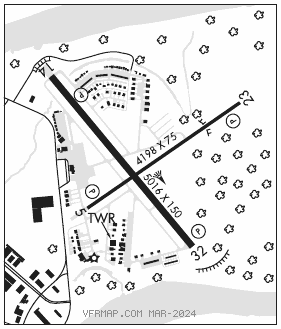
RWY 14–32: H5016X150 (ASPH) S–35, D–55 HIRL
RWY 14: REIL. PAPI(P4L)—GA 3.0° TCH 43′. Trees.
RWY 32: REIL. PAPI(P4R)—GA 3.0° TCH 27′. Trees.
RWY 05–23: H4198X75 (ASPH) S–12.5 MIRL
RWY 05: REIL. PAPI(P2L)—GA 3.0° TCH 42′. Fence.
RWY 23: REIL. PAPI(P2L)—GA 3.0° TCH 39′. Trees.
SERVICE: S4 FUEL 100LL, JET A OX 2, 3 LGT Rwy 05 REIL OTS indef. Rwy 23 REIL OTS indef. Rwy 14 PAPI unusable byd 8° right of centerline.
AIRPORT REMARKS: Attended 1300–0400Z‡. 100LL avbl 24 hrs self svc with credit card. For Jet A after hrs call 318–510–4330. Avbl 24 hrs self svc with credit card. All VFR tfc remain within 1 1/2 miles northeast thru southwest from the center of the arpt due to Shreveport/Barksdale AFB CLASS C airspace. Wildlife–deer & birds on & invof arpt. Rwy 14 designated calm wind rwy. Acft/vehicles not vsbl from ATCT on N 685 ft of Twy F.
AIRPORT MANAGER: 318-349-8330
WEATHER DATA SOURCES: ASOS 118.525 (318) 425–7967.
COMMUNICATIONS: CTAF 120.225 UNICOM 122.95
SHREVEPORT RCO 122.6 (DE RIDDER RADIO)
®SHREVEPORT APP/DEP CON 119.9 (153°–319°) 123.75 (320°–152°)
CLNC DEL 121.65 (When ATCT clsd CLNC DEL provided by SHV DEP CON on 119.9)
TOWER 120.225 (1300–0400Z‡) GND CON 121.65
AIRSPACE: CLASS D svc 1300–0400Z‡; other times CLASS G.
RADIO AIDS TO NAVIGATION: NOTAM FILE SHV.
BELCHER (H) (H) VORTACW 117.4 EIC Chan 121 N32°46.28′ W93°48.60′ 159° 14.2 NM to fld. 190/7E.
LOC/DME 111.7 I–DTN Chan 54 Rwy 14.