BEAUREGARD RGNL (DRI)(KDRI) 3 SW UTC–6(–5DT) N30°49.90′ W93°20.39′
202 B TPA—1202(1000) NOTAM FILE DRI
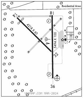
RWY 18–36: H5494X100 (ASPH–CONC–AFSC) S–60 MIRL
RWY 18: REIL. PAPI(P4R)—GA 3.0° TCH 50′. Trees.
RWY 36: ODALS. PAPI(P4L)—GA 3.0° TCH 50′. Trees.
RWY 14–32: H4218X60 (ASPH)
RWY 14: Thld dsplcd 454′. Trees.
RWY 32: Trees.
SERVICE: S2 FUEL 100LL, JET A LGT REIL Rwy 18 andMIRL Rwy 18–36 preset low intst dusk–dawn; to incr intst ACTVT—CTAF.
AIRPORT REMARKS: Attended Mon–Fri 1400–2300Z‡. For attendant other times call 337–401–2967. 100LL avbl 24 hrs self svc with credit card. For Jet A aft hrs and hols call 337–401–2967. Rwy 18 and Rwy 36 markings faded.
AIRPORT MANAGER: 337-463-8250
WEATHER DATA SOURCES: AWOS–3PT 118.225 (337) 463–8278.
COMMUNICATIONS: CTAF/UNICOM 122.8
®POLK APP/DEP CON 123.7
CLEARANCE DELIVERY PHONE: For CD if una to ctc on FSS freq, ctc Polk Apch at 337-531-2352.
RADIO AIDS TO NAVIGATION: NOTAM FILE LCH.
LAKECHARLES (H)(H)VORTACW 113.4 LCH Chan 81 N30°08.49′ W93°06.33′ 337° 43.1 NM to fld. 20/7E.
VOR unusable:
181°–359° byd 30 NM blo 1,500′
DERIDDERNDB (MHW) 385 DXB N30°45.13′ W93°20.08′ 353° 4.8 NM to fld. 164/4E. NOTAM FILE DRI.NDB unmonitored 0100–1300Z‡.
LOC 111.1 I–DRI Rwy 36. LOC unmonitored 0100–1300Z‡.