DELANO MUNI (DLO)(KDLO) 2 SE UTC–8(–7DT) N35°44.73′ W119°14.19′
316 B TPA–1116(800) NOTAM FILE RIU
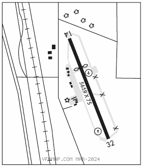
RWY 14–32: H5659X75 (ASPH) S–30 MIRL
RWY 14: REIL. PAPI(P2L)–GA 3.5°. Thld dsplcd 1629′. Road. Rgt tfc.
RWY 32: REIL. PAPI(P2L)–GA 3.0°.
SERVICE: S6 FUEL 100LL LGT MIRL Rwy 14–32 preset low ints SS–SR, to increase ints ACTIVATE–CTAF.
AIRPORT REMARKS: Attended 1600–0100Z‡. After hrs emerg ctc Police Department 661–721–3377. Seasonal crop duster ops on arpt east of Rwy 14–32. Area east of rwy is rstd AG use only.
AIRPORT MANAGER: 661-720-2219
WEATHER DATA SOURCES: AWOS–3P 119.55 (661) 721–2668.
COMMUNICATIONS: CTAF/UNICOM 122.8
®BAKERSFIELD APP/DEP CON 118.9 (1400–0700Z‡) other times ctc
L.A. CENTER APP/DEP CON 127.1 (0700–1400Z‡)
CLEARANCE DELIVERY PHONE: For CD ctc Los Angeles ARTCC at 661-575-2079.
RADIO AIDS TO NAVIGATION: NOTAM FILE BFL.
SHAFTER (VH) (H) VORTACW 115.4 EHF Chan 101 N35°29.07′ W119°05.84′ 323° 17.1 NM to fld. 549/14E.
VOR unusable:
029°–106° byd 40 NM
108°–131° byd 40 NM
132°–142° byd 40 NM blo 10,000′
132°–142° byd 70 NM
153°–180° byd 40 NM
232°–249° byd 40 NM
327°–347° byd 40 NM blo 9,000′
327°–347° byd 67 NM blo 18,000′