DOUGLAS
CONVERSE CO (DGW)(KDGW) 3 N UTC–7(–6DT) N42°47.83′ W105°23.15′ 4933 B NOTAM FILE DGW MON Airport
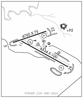
RWY 11–29: H6534X100 (ASPH) MIRL 0.4% up SE
RWY 11: REIL. PAPI(P2L)–GA 3.0° TCH 33′.
RWY 29: REIL. PAPI(P2L)–GA 3.0° TCH 45′.
RWY 05–23: 4760X75 (GRVL–DIRT) S–12.5 MIRL 0.3% up NE
RWY 23: PAPI(P2L)–GA 3.0° TCH 45′. Hill.
SERVICE: S4 FUEL 100LL, JET A LGT ACTVT REIL Rwys 11 and 29; MIRL Rwy 05–23 and 11–29 dalgt hrs–122.8. MIRL Rwy 05–23 and 11–29 preset to low intst dark hrs, to incr intst–122.8. PAPI Rwy 11, 23 and 29 opr consly.
AIRPORT REMARKS: Attended Mon–Fri 1330–0000Z‡, Sat–Sun 1500–0000Z‡. Fuel after hrs see phone numbers posted in trml lobby. Call out fee will apply. Wildlife on and invof arpt. Retro–reflective markers along all twys.
AIRPORT MANAGER: 307-358-4924
WEATHER DATA SOURCES: ASOS 135.225 (307) 358–4448. Opr full–time 0700–0659Z‡.
COMMUNICATIONS: CTAF/UNICOM 122.8
DOUGLAS RCO 122.4 (CASPER RADIO)
®DENVER CENTER APP/DEP CON 135.6
CLEARANCE DELIVERY PHONE: For CD if una to ctc on FSS freq, ctc Denver ARTCC at 303-651-4257.
RADIO AIDS TO NAVIGATION: NOTAM FILE DGW.
HIPSHER (VL) (DH) VORW/DME 115.75 IIP Chan 104(Y) N42°40.57′ W105°13.57′ 304° 10.1 NM to fld. 4906/12E.
VOR unusable:
165°–309° byd 40 NM
310°–320° byd 40 NM blo 8,300′
310°–320° byd 53 NM
321°–334° byd 40 NM
335°–345° byd 40 NM blo 7,500′
335°–345° byd 56 NM
346°–040° byd 40 NM