DAYTONA BEACH INTL (DAB)(KDAB) 3 SW UTC–5(–4DT) N29°10.79′ W81°03.48′
34 B TPA–See Remarks Class I, ARFF Index C NOTAM FILE DAB
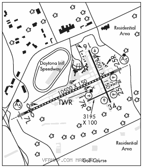
RWY 07L–25R: H10500X150 (ASPH–CONC–GRVD) S–120, D–224, 2S–175, 2D–402, 2D/2D2–915 PCN 66 R/B/W/T HIRL CL
RWY 07L: MALSR. TDZL. RVR–T Thld dsplcd 690′. Road.
RWY 25R: MALSR. PAPI(P4L)–GA 3.0° TCH 72′. RVR–R Trees. Rgt tfc.
RWY 16–34: H6001X150 (ASPH–GRVD) S–120, D–225, 2S–175, 2D–385, 2D/2D2–892 PCN 58 F/B/W/T MIRL
RWY 16: REIL. PAPI(P4L)–GA 3.0° TCH 50′. Trees.
RWY 34: REIL. PAPI(P4L)–GA 3.0° TCH 50′. Trees.
RWY 07R–25L: H3195X100 (ASPH) S–24, D–38.5 PCN 7 F/B/Y/T MIRL
RWY 07R: REIL. PAPI(P2L)–GA 3.0° TCH 48′. Trees. Rgt tfc.
RWY 25L: REIL. PAPI(P2L)–GA 3.0° TCH 44′. Trees.
LAND AND HOLD–SHORT OPERATIONS
LDG RWY HOLD–SHORT POINT AVBL LDG DIST
RWY 07L TWY W 7500
RWY 16 07L–25R 2900
RWY 34 07L–25R 2564
RUNWAY DECLARED DISTANCE INFORMATION
RWY 07L:TORA–10500 TODA–10500 ASDA–10500 LDA–9810
RWY 07R:TORA–3195 TODA–3195 ASDA–3195 LDA–3195
RWY 16: TORA–6001 TODA–6001 ASDA–5969 LDA–5969
RWY 25L:TORA–3195 TODA–3195 ASDA–3195 LDA–3195
RWY 25R:TORA–10500TODA–10500 ASDA–10293 LDA–10293
RWY 34: TORA–6001 TODA–6001 ASDA–6001 LDA–6001
SERVICE: S4 FUEL 100LL, JET A OX 1 LGT Rwy 25R PAPI unusbl byd 5 deg left and right of cntrln.
NOISE: Use co fly quiet proc or rcmd noise abatement proc – amgr.
AIRPORT REMARKS: Attended continuously. Flt trng and birds on and invof and drone act NE of arpt; birds over landfill 3.5 NM SW. DAB Twy C1 clsd to acft wingspan more than 119 ft; Twy W clsd to acft wingspan more than 119 ft; Twy W3 clsd to acft wingspan more than 79 ft. PPR for Daytona Beach Speedway low apch or fly–over–DAB ATC. Sfc cond not mntd 0200–1000Z‡. First 2300 ft Rwy 07L concrete on 50 ft wide keel section. Rwy 07R–25L outer edges of pavement uneven. Rwy 07R–25L sked acr ops more than 9 pax seats or unsked acr at least 31 pax seats na. TPA–TPA for lgt acft 965 ft AGL; TPA for hi per acft 1365 ft AGL. Twy N northwest of Rwy 07L and northeast of Rwy 25R can be mistaken for rwy and apch environment. Twy S east end is non–movement area. Twy E rstrd to 22,000 lbs max crtfyd gross tkof weight; Twy P rstrd to 190,500 lbs max crtfyd gross tkof weight. Twy W btn apch end Rwy 16 and Twy A clsd to mil hel ops and hover tax ops. Twy W btn Twy A and apch end Rwy 16 clsd to rotary wing acft rotar span more than 50 ft exc 1 hr PPR 386–527–0657. Rotor wing hel must grnd taxi; if unabl use ctn durg hover taxi. Twy W btn Rwy 16 apch end and Twy A clsd to mil hel and hover taxi ops. Twy W btn Twy A and Rwy 16 apch end clsd to rotary wing with rotar span more than 50 ft exc 1 hr PPR–386–527–0657. US CUSTS ramp Rrstd Group II acft of wingspan 79 ft or less. Twy P3 and P4 have no signs or marking.
AIRPORT MANAGER: 386-248-8030
WEATHER DATA SOURCES: ASOS (386) 257–6444 LLWAS.
COMMUNICATIONS: ATIS 132.875 UNICOM 122.95
®APP CON 118.85 (North 4000′–7500′) 125.35 (South 3500′and blo) 127.075 (South 4000′–7500′) (125.725 (8000′–11000′) 125.8 (North 3500′ and blo)
TOWER 120.7 GND CON 121.9 CLNC DEL 119.3
AIRSPACE: CLASS C svc ctc APP CON.
VOR TEST FACILITY (VOT) 111.0
RADIO AIDS TO NAVIGATION: NOTAM FILE OMN.
ORMOND BEACH (VH) (H) VORTAC 112.6 OMN Chan 73 N29°18.20′ W81°06.76′ 159° 7.9 NM to fld. 24/0E.
VOR unusable:
034°–036° byd 40 NM
070°–100° byd 35 NM blo 1,500′
099°–112° byd 40 NM
122°–141° byd 40 NM
159°–161° byd 40 NM
170°–181° byd 40 NM blo 3,000′
170°–181° byd 46′
207°–209° byd 40 NM
236°–239° byd 40 NM
240°–244° blo 6,000′
240°–250° byd 53 NM
251°–286° byd 40 NM
290°–298° byd 40
290°–300° byd 20 NM blo 2,500′
318°–321° byd 40 NM
326°–328° byd 40 NM
ILS 109.7 I–DAB Rwy 07L. Class IA. Auto cpd apch NA blw 535′ MSL due to glideslope reversal
ILS/DME 109.7 I–DBF Chan 34 Rwy 25R. Class IE.
ASR