CHARLEVOIX MUNI (CVX)(KCVX) 1 SW UTC–5(–4DT) N45°18.29′ W85°16.52′
669 B NOTAM FILE CVX
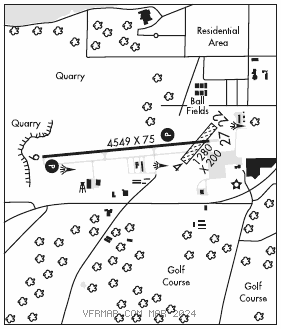
RWY 09–27: H4549X75 (ASPH) S–12.5 MIRL(NSTD) 0.6% up W
RWY 09: REIL. PAPI(P4R)—GA 3.0° TCH 39′.
RWY 27: REIL. PAPI(P4R)—GA 3.0° TCH 31′. Tree.
RWY 04–22: 1280X200 (TURF) 0.5% UP SW
RWY 04: Trees.
RWY 22: Tree.
SERVICE: S4 FUEL 100LL, JET A+ LGT Actvt REIL Rwy 09 and 27; PAPI Rwy 09 and 27; NSTD MIRL Rwy 09–27—CTAF. NSTD MIRL due to Rwy 27 thr lgts lctd outboard fm rwy edges.
NOISE: Charlevoix voluntary quiet hrs WEF 0400–1200Z‡.
AIRPORT REMARKS: Attended Jun–Aug 1300–0000Z‡, Sep–May 1300–2200Z‡. Unattended major holidays. Rwy 04–22. CLOSED Nov–Apr. Deer and birds on and invof arpt. For 100LL aft call AMGR. Rwy 09 preferred rwy for landing 2300–0700Z‡. Rwy 27 preferred rwy for takeoff 2300–0700Z‡. Rwy 04 and 22 mkd with 3′ yellow cones. Rwy 09–27 upslopes from east to west, steepest grad occurs west third of rwy. –100′ quarry/mine, 300′ from Rwy 9 thld. Landing fee waived with minimum fuel purchase.
AIRPORT MANAGER: 231-547-3605
WEATHER DATA SOURCES: AWOS–3P 120.0 (231) 237–9703.
COMMUNICATIONS: CTAF/UNICOM 122.8
®MINNEAPOLIS CENTER APP/DEP CON 134.6
CLEARANCE DELIVERY PHONE: For CD ctc Minneapolis ARTCC at 651-463-5588.
RADIO AIDS TO NAVIGATION: NOTAM FILE PLN.
PELLSTON (L) (L) VORTACW 111.8 PLN Chan 55 N45°37.84′ W84°39.85′ 239° 32.4 NM to fld. 836/6W.
VOR unusable:
301°–339°
GCP has azm only, no DME at GCP