CLINTON/SHERMAN (CSM)(KCSM) 2 SW UTC–6(–5DT) N35°20.39′ W99°12.03′
1922 B NOTAM FILE CSM
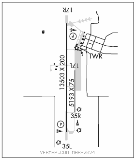
RWY 17R–35L: H13503X200 (CONC) S–50, D–200, 2S–175, 2D–390 HIRL(NSTD)
RWY 17R: REIL. PAPI(P4L)—GA 3.0° TCH 54′. Rgt tfc.
RWY 35L: REIL. PAPI(P4L)—GA 3.0° TCH 50′.
RWY 17L–35R: H5193X75 (CONC) S–50, D–200, 2S–175, 2D–390
RWY 35R: Rgt tfc.
SERVICE: S4 FUEL JET A OX 3 LGT Actvt REIL 17R and 35L; HIRL Rwy 17R–35L; Twy lgt; wdi lgt—CTAF. PAPI Rwy 17R and 35L on consly. Rwy 17R–35L nstd; 75′ fm rwy edge.
AIRPORTREMARKS:Attended Mon–Fri 1500–0700Z‡. ATCT clsd fed hol. 24 hr Jet–A fuel and otr svc avbl–ctc 405–267–4010. Rwy 17L–35R laid out and mrkd on Rwy 17L–35R parl twy. Rwy 17L–35R dalgt VFR only. Mil jet trng: hvy jets sfc to 5000′ wi 25 NMR. Extsv student pilot trng fm sfc to 5000′ wi 10 NMR btn 1500–1800Z‡. Mil jet ngt vision trng: ctc ATCT 10 mins prior to ldg aft SS to adjust arpt lgts. VFR acft adzd to ctc ATC 15 NM out for seqg. Ldg fee for acft gtr than 50,000 lbs. See Special Notices—Space Launch Activity Area.
AIRPORT MANAGER: 580-309-3223
WEATHER DATA SOURCES: ASOS 118.450 (580) 562–4811. LAWRS.
COMMUNICATIONS: CTAF 119.6 UNICOM 122.95
CLINTON–SHERMAN RCO 122.5 (MC ALESTER RADIO)
®FORT WORTH CENTER APP/DEP CON 128.4
TOWER 119.6 (1500–0700Z‡ Mon–Fri; except federal holidays.) GND CON 121.7
AIRSPACE: CLASS D svc 1500–0700Z‡ Mon–Fri, exc fed hol; other times CLASS G.
RADIO AIDS TO NAVIGATION: NOTAM FILE CSM.
BURNS FLAT (L) (L) VORTACW 110.0 BFV Chan 37 N35°14.22′ W99°12.37′ 358° 6.2 NM to fld. 1780/5E.
FOSSI NDB (MHW/LOM) 393 BZ N35°27.04′ W99°12.09′ 175° 6.6 NM to fld. 5E. NDB unmonitored when Clinton–Sherman ATCT closed.
ILS 109.5 I–BZF Rwy 17R. LOM FOSSI NDB. ILS and NDB/LOM unmonitored when ATCT closed.