CHATHAM MUNI (CQX)(KCQX) 2 NW UTC–5(–4DT) N41°41.30′ W69°59.38′
64 B NOTAM FILE CQX
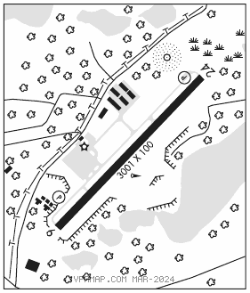
RWY 06–24: H3001X100 (ASPH) S–30 MIRL 0.5% up NE
RWY 06: REIL. PAPI(P2L)–GA 3.5° TCH 39′. Trees.
RWY 24: REIL. PAPI(P2R)–GA 3.5° TCH 39′. Tank.
SERVICE: S3 FUEL 100LL, JET A, A+ LGT Actvt MIRL Rwy 06–24–122.95.
NOISE: Noise abatement Rwy 06–24. Use full rwy and avoid intersection departures. Minimize/avoid touch and go ldg opns. Climb out on rwy heading until 1000′ over water then proceed on course. Reduce power as soon as practical. Rwy 06–24, fly pattern downwind leg 1/2 to 1 mile out from rwy as practicable.
AIRPORT REMARKS: Attended 1300Z‡–dusk. Birds, primarily gulls and wildlife on or invof arpt. Be aware of hi–speed mil jet and heavy helicopter tfc invof Cape Cod CGAS. Avoid residential areas as much as possible. Recommended minimum alt 2000′ AGL from northeast to southeast of arpt over national seashore. Water ldg area clsd perm.
AIRPORT MANAGER: 508-945-9000
WEATHER DATA SOURCES: ASOS 135.875 (508) 945–5034.
COMMUNICATIONS: CTAF/UNICOM 122.8
®BOSTON CONSOLIDATED TRACON APP/DEP CON 118.2 (1000–0500Z‡)
CLNC DEL 127.3
®BOSTON CENTER APP/DEP CON 128.75 (0500–1000Z‡)
CLEARANCE DELIVERY PHONE: For CD ctc Boston Apch at 603-594-5554.
RADIO AIDS TO NAVIGATION: NOTAM FILE BDR.
MARCONI (VH) (DH) VORW/DME 114.7 LFV Chan 94 N42°01.03′ W70°02.23′ 190° 19.8 NM to fld. 151/16W.
VOR unusable:
245°–250° byd 40 NM
NAUSET NDB (MHW) 279 CQX N41°41.52′ W69°59.26′ at fld. 56/16W. NOTAM FILE CQX.
NDB unusable:
220°–280° byd 20 NM