CHANUTE MARTIN JOHNSON (CNU)(KCNU) 2 SW UTC–6(–5DT) N37°40.07′ W95°29.20′
1003 B NOTAM FILE CNU
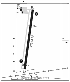
RWY 18–36: H4254X75 (ASPH) S–12 PCN 5 F/C/Y/U MIRL 0.5% up S
RWY 18: REIL. PAPI(P2L)–GA 3.0° TCH 40′. Tree.
RWY 36: REIL. PAPI(P2L)–GA 3.0° TCH 40′. Thld dsplcd 269′. Railroad.
SERVICE: FUEL 100LL, JET A LGT ACTIVATE REIL Rwy 18 and Rwy 36; PAPI Rwy 18 and Rwy 36; MIRL Rwy 18–36–CTAF. Rotating bcn opr dusk–0500Z‡.
AIRPORT REMARKS: Attended Mon–Sat 1400–2300Z‡, Sun 1800–2300Z‡. For after hrs emergency call 620–305–9689. Ultralight activity, birds and wildlife on and invof arpt. Courtesy car avbl.
AIRPORT MANAGER: 620-305-9689
WEATHER DATA SOURCES: ASOS 127.075 (620) 431–6781.
COMMUNICATIONS: CTAF/UNICOM 122.7
RCO 122.2 (WICHITA RADIO)
®KANSAS CITY CENTER APP/DEP CON 132.9
CLEARANCE DELIVERY PHONE: For CD if una to ctc on FSS freq, ctc Kansas City ARTCC at 913-254-8508.
AIRSPACE: CLASS E svc 1200–0400Z‡; other times CLASS G.
RADIO AIDS TO NAVIGATION: NOTAM FILE CNU.
(L) (L) VORW/DME 109.2 CNU Chan 29 N37°37.57′ W95°35.61′ 059° 5.7 NM to fld. 1085/5E.