CHIPPEWA CO INTL (CIU)(KCIU) 15 S UTC–5(–4DT) N46°15.05′ W84°28.34′
799 B TPA—1599(800) LRA ARFF Index—See Remarks NOTAM FILE CIU
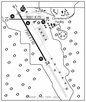
RWY 16–34: H7203X150 (ASPH–CONC–GRVD) S–155, D–330, 2S–175, 2D–600 PCN 31 R/B/X/U HIRL
RWY 16: MALSR. PAPI(P4L)—GA 3.0° TCH 57′. Rgt tfc.
RWY 34: REIL. PAPI(P4L)—GA 3.0° TCH 41′.
RWY 10–28: H5001X75 (ASPH–GRVD) S–100, D–100 PCN 15 F/B/Y/U MIRL
RWY 10: REIL. PAPI(P4L)—GA 3.0° TCH 40′. Trees.
RWY 28: REIL. PAPI(P4L)—GA 3.0° TCH 40′. Trees.
RUNWAY DECLARED DISTANCE INFORMATION
RWY 10: TORA–5000 TODA–5000 ASDA–5000 LDA–5000
RWY 16: TORA–7203 TODA–7203 ASDA–7203 LDA–7203
RWY 28: TORA–5000 TODA–5000 ASDA–5000 LDA–5000
RWY 34: TORA–7203 TODA–7203 ASDA–7203 LDA–7203
SERVICE: FUEL 100LL, JET A LGT Actvt MALSR Rwy 16; REIL Rwy 34, 10, & 28; PAPI Rwy 16, 34, 10, & 28; HIRL Rwy 16–34; MIRL Rwy 10–28—CTAF. REIL & PAPI Rwy 34 opr consly Dec–Mar; PAPI Rwy 10 & 28 opr consly drg dalgt hrs. Rwy end 28: PAPI unusbl byd 8 degs left of ccntrln.
AIRPORT REMARKS: Attended 1100–2300Z‡. Birds on and invof arpt. Ficons unmon 0200–1200Z‡. 24 hr PPR for unsked acr ops gtr than 9 pax seats – call amgr. Class I, ARFF Index A. ARFF coverage provided scheduled FAR 121 acft only, other times by prior arrangement with airport manager. Rwy 16–34 cntr 150 ft is asph, rmng outside edges are conc. Exp snow removal act dly Dec–Mar. Vehicle testing inpr drg winter months on sections of clsd/abndd parl twy, SE of apch end Rwy 34. Area may be plowed to bare sfc but unavbl for arr or dep. Flight Notification Service (ADCUS) available.
AIRPORT MANAGER: 906-495-5631
WEATHER DATA SOURCES: AWOS–3PT 127.575 (906) 495–1156.
COMMUNICATIONS: CTAF/UNICOM 123.0
CHIPPEWA RCO 122.6 (GREEN BAY RADIO)
SAULT STE MARIE RCO 122.1R 112.2T (GREEN BAY RADIO)
TORONTO CENTER APP/DEP CON 132.65
CLEARANCE DELIVERY PHONE: For CD if una to ctc on FSS freq, ctc Minneapolis ARTCC at 651-463-5588.
AIRSPACE: CLASS E.
RADIO AIDS TO NAVIGATION: NOTAM FILE CIU.
SAULT STE MARIE (VH) (DH) VOR/DME 112.2 SSM Chan 59 N46°24.73′ W84°18.89′ 218° 11.7 NM to fld. 687/4W.
VOR unusable:
007°–034° byd 40 NM
052°–095° byd 40 NM
085°–105° byd 10 NM blo 5,000′
085°–105° byd 20 NM blo 8,000′
124°–134° byd 40 NM
157°–167° byd 40 NM blo 2,900′
157°–167° byd 46 NM
207°–216° byd 40 NM
329°–344° byd 40 NM
354°–004° byd 40 NM
KOLOE NDB (MH/LOM) 400 CI N46°19.95′ W84°32.55′ 156° 5.7 NM to fld. 644/7W. NOTAM FILE GRB. NDB unmtd
ILS 110.3 I–CIU Rwy 16. Class IA. LOM KOLOE NDB. Unmonitored. Glideslope unusable blw 1,090′. LOC unusable wi 0.6 NM. Autopilot cpd apch NA blw 1,380′.