CRYSTAL RIVER–CAPT TOM DAVIS FLD (CGC)(KCGC) 3 SE UTC–5(–4DT) N28°52.06′ W82°34.45′
9 B NOTAM FILE CGC
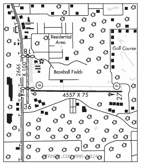
RWY 09–27: H4557X75 (ASPH) S–68, D–97 PCN 23 F/A/X/T MIRL
RWY 09: REIL. PAPI(P4L)–GA 3.0° TCH 44′. Road.
RWY 27: REIL. PAPI(P2R)–GA 3.0° TCH 43′. Brush.
RWY 18–36: 2666X100 (TURF)
RWY 18: Thld dsplcd 192′. Bldg.
RWY 36: Thld dsplcd 819′. Fence.
SERVICE: S2 FUEL 100LL, JET A LGT Actvt REIL Rwys 09 and 27; MIRL Rwy 09–27–CTAF.
AIRPORT REMARKS: Attended 1300–2300Z‡. Aerobatic actvt along N side of Rwy 09–27 and 4 NM SW of arpt. Ctc unicom for tfc info, and NOTAMs or FSS for specific times. Glider ops within 25 NM. Rwy 18–36 dsplcd thld marked with green pipes. Bldgs and fence 40′ from cntrln both sides of dsplcd thld. Rwy 18–36 marked with white pipes every 200′. Bldg 30–80′ West of AER Rwy 18. Rwy 27 trees on both sides of rwy in transition sfc.
AIRPORT MANAGER: 352-527-5247
WEATHER DATA SOURCES: AWOS–3 118.325 (352) 563–6600.
COMMUNICATIONS: CTAF/UNICOM 122.725
®JACKSONVILLE APP/DEP CON 118.6
CLEARANCE DELIVERY PHONE: For CD ctc Jacksonville Apch at 904-741-0284.
RADIO AIDS TO NAVIGATION: NOTAM FILE OCF.
OCALA (VL) (L) VORTAC 113.7 OCF Chan 84 N29°10.65′ W82°13.58′ 225° 26.0 NM to fld. 78/0E.
TACAN AZIMUTH unusable:
025°–078°
329°–350°
351°–024° byd 28NM
VOR unusable:
010°–024° byd 40 NM
030°–037° byd 40 NM
053°–060° byd 40 NM
065°–077° byd 40 NM
094°–108° byd 40 NM blo 3,000′
094°–108° byd 66 NM
127°–137° byd 40 NM
157°–171° byd 40 NM blo 13,000′
157°–171° byd 75 NM
177°–187° byd 40 NM blo 2,000′
177°–187° byd 54 NM
193°–210° byd 40 NM
219°–244° byd 40 NM
277°–298° byd 40 NM
325°–335° byd 40 NM blo 10,000′
325°–335° byd 76 NM
352°–005° byd 111 NM
352°–005° byd 40 NM blo 12,000′