CRAIG–MOFFAT (CAG)(KCAG) 2 SE UTC–7(–6DT) N40°29.71′ W107°31.30′
6198 B NOTAM FILE CAG MON Airport
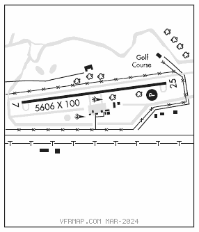
RWY 07–25: H5606X100 (ASPH) S–35, D–40 PCN 12 F/D/X/T MIRL
RWY 07: REIL. P–line.
RWY 25: REIL. PAPI(P4L)–GA 3.0° TCH 32′. Tree.
SERVICE: FUEL 100LL, JET A LGT MIRL Rwy 07–25 preset low ints, to increase ints and ACTIVATE MIRL Rwy 07–25, REIL Rwy 07 and Rwy 25, and PAPI Rwy 25–CTAF.
AIRPORT REMARKS: Attended Mon–Fri 1500–0000Z‡ Sat–Sun irregularly. Wildlife on and invof arpt. Rwy 25 has +10′ road 340′ from thld obstruction, +41′ trees 1185′ from thld 50′ left of centerline, +75′ trees 4000′ from thld. Cold temperature airport. Altitude correction required at or below –31C.
AIRPORT MANAGER: 970-824-9148
WEATHER DATA SOURCES: ASOS 135.425 (970) 824–2373.
COMMUNICATIONS: CTAF/UNICOM 122.8
®DENVER CENTER APP/DEP CON 120.475
CLEARANCE DELIVERY PHONE: For CD ctc Denver ARTCC at 303-651-4257.
RADIO AIDS TO NAVIGATION: NOTAM FILE DEN.
HAYDEN (VH) (H) VORW/DME 115.6 CHE Chan 103 N40°31.20′ W107°18.29′ 248° 10.0 NM to fld. 7271/14E.
VOR unusable:
036°–046° byd 40 NM blo 14,200′
036°–046° byd 49 NM
047°–070° byd 40 NM
071°–081° byd 40 NM blo 13,000′
071°–081° byd 60 NM
130°–208° byd 40 NM