BALTIMORE
BALTIMORE/WASHINGTON INTL THURGOOD MARSHALL (BWI)(KBWI) 9 S UTC–5(–4DT) N39°10.54′ W76°40.14′ 143 B LRA Class I, ARFF Index D NOTAM FILE BWI
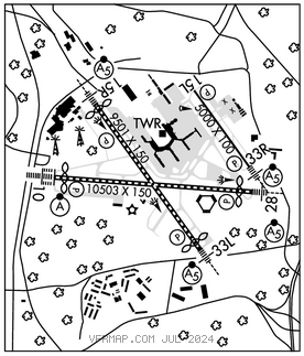
RWY 10–28: H10503X150 (ASPH–GRVD) S–80, D–220, 2D–1020, 2D/2D2–1340 PCR 759 F/A/X/T HIRL CL
RWY 10: ALSF2. TDZL. PAPI(P4R)–GA 3.0° TCH 71′. RVR–TMR Thld dsplcd 550′. Tree.
RWY 28: MALSR. PAPI(P4L)–GA 3.0° TCH 75′. RVR–TMR Thld dsplcd 700′. Tree. 0.3% up.
RWY 15R–33L: H9501X150 (ASPH–GRVD) S–80, D–220, 2D–675, 2D/2D2–890 PCR 759 F/A/X/T HIRL CL
RWY 15R: MALSR. PAPI(P4R)–GA 3.0° TCH 73′. RVR–TMR Thld dsplcd 301′. Antenna.
RWY 33L: MALSR. TDZL. PAPI(P4L)–GA 3.0° TCH 72′. RVR–TMR Thld dsplcd 500′. Tower.
RWY 15L–33R: H5000X100 (ASPH–GRVD) S–30, D–45 PCR 269 F/A/X/T HIRL 0.5% up NW
RWY 15L: REIL. PAPI(P4L)–GA 3.0° TCH 47′. RVR–TR Pole.
RWY 33R: MALSR. REIL. PAPI(P4L)–GA 3.0° TCH 47′. RVR–TR Tree.
RUNWAY DECLARED DISTANCE INFORMATION
RWY 10: TORA–10503 TODA–10503 ASDA–10503 LDA–9953
RWY 15L:TORA–5000 TODA–5000 ASDA–5000 LDA–5000
RWY 15R:TORA–9501 TODA–9501 ASDA–8601 LDA–8301
RWY 28: TORA–10503 TODA–10503 ASDA–10503 LDA–9803
RWY 33L:TORA–9501 TODA–9501 ASDA–8801 LDA–8301
RWY 33R:TORA–5000 TODA–5000 ASDA–5000 LDA–5000
SERVICE: S4 FUEL 100LL, JET A OX 1, 2, 3, 4
NOISE: Noise abatement procedures in effect–Rstrn for Rwy 15L–33R except for emerg or Mercy flights ctc amgr for info.
AIRPORT REMARKS: Attended continuously. Deer and birds ocnly on and invof arpt. Major constr on arpt dly; acft mov and prkg areas subject to short notice change/closure. For current info phone BWI opns cntr 410–859–7018. Rwy status lgts in operation. Practice lndg & apch by turbo–pwrd acft prohibited 0300–1100Z‡; practice lndg & tkof by B–747 acft prohibited Rwy 15R–33L. Rwy length avbl for Rwy 28 departures from Twy U1 is 9802 ft. ASDE–X in use. Operate transponders with alt reporting mode and ADS–B (if equipped) enabled on all arpt surfaces. Acft departing Rwy 28 exp dep from Twy U1. No apron parking for unscheduled air carriers. General aviation acft ctc UNICOM prior to arr at General Aviation ramp for security purposes. Midfield RVR sensor shared by Rwy 10–28 & Rwy 15R–33L. Taxiing prohibited btn concourse C and adjacent bldg structure SW of concourse C. Access to gate C12 must be via Twy A. Taxilanes T–1 and H, rstd to Group III acft with max wingspan of 118 ft. Twy A is rstrd to group IV acft wingspan 171 ft or less. Twy T btn Twy H and Twy E rstrd to Group IV acft with wingspan less than 171 ft. Twy T btn Twy E and Twy B rstrd to Group V acft with wingspan less than 214 ft; when Group V acft are on Twy T, Twy A is rstrd to max wingspans of 110 ft. Twy S, south of Twy P, rstrd to acft 60,000 lbs & less. Dual parallel taxilanes have been added to the D/E alleyway, Taxilane N and Taxilane N1. Taxilane N is designated a Group V taxilane with max wingspan of 213 ft. Taxilane N1 is designated a Group IV taxilane with a max wingspan of 170 ft. Rwy 15L–33R rstd to acft producing less than 90 decibels exc for emergs. Cont mowing operations adj all rwys & twys Apr thru Nov. Distracting lgts (golf driving range) right side extdd cntrln Rwy 33L fm AER to 1/4 mi final. Acft on visual apchs expect to maintain 3000 ft until 10 DME fm BAL VORTAC; dep acft should expect turns based on Baltimore DME. Rwy 15R deice pad, Position # 1 rstrd to acft with wingspan of 156 ft 1 inch or less & length of 180 ft 3 inches or less. Psn′s # 2 & # 3 are rstd to acft with a wingspan of 156 ft 1 inch or less, Position # 3 is rstd to acft with a wingspan of 156 ft 1 inch or less & length of 180 ft 3 inches or less; Position # 4 rstrd to acft with wingspan of 213 ft or less & length of 229 ft 2 inches or less. Rwy 28 de–ice pad Lane 1 rstrd to acft with wingspan 171 ft or less, Lane 2 rstrd to acft with wingspan 135 ft or less, Lane 3 is used by large acft max wingspan 215 ft and when in use–Lanes 2 and 4 are unavbl. Lanes 4, 5 & 6 are rstrd to acft wingspan 135 ft or less. Concourse A alt deicing area is rstrd to B737–800 size acft with winglets or smlr on spots 6, 7 and 8. B737–700 size acft with winglets or smaller are rstd to spots 6A, 7B and 8B. Ldg fee. Flight Notification Service (ADCUS) avbl.
AIRPORT MANAGER: 410-859-7024
WEATHER DATA SOURCES: ASOS (410) 691–1278 TDWR.
COMMUNICATIONS: D–ATIS 115.1 127.8 UNICOM 119.4
BALTIMORE RCO 122.2 (LEESBURG RADIO)
®POTOMAC APP CON 119.0 (020°–130°) 119.7 (131°–180°) 124.55 (101°–130°) 128.7 (181°–019°) 119.0 (131°–180°) 119.7 (020°–130°) 125.525 (181°–019°)
BALTIMORE TOWER 119.4 GND CON 121.9 CLNC DEL 118.05
®POTOMAC DEP CON 124.55 (East) 128.7 (West)
CPDLC (LOGON KUSA)
PDC
AIRSPACE: CLASS B See VFR Terminal Area Chart.
RADIO AIDS TO NAVIGATION: NOTAM FILE BWI.
(L) (L) VORTACW 115.1 BAL Chan 98 N39°10.26′ W76°39.68′ at fld. 15011W.
DME unusable:
133°–155° byd 20 NM blo 10,000′
133°–155° byd 36 NM
300°–349° byd 35 NM
VOR unusable:
133°–155° byd 20 NM blo 10,000′
197°–217° byd 17 NM
260°–281° byd 15 NM
282°–292°
TACAN AZIMUTH unusable:
029°–042° byd 30 NM
133°–155° byd 20 NM blo 10,000′
180°–190° byd 17 NM
300°–349° byd 35 NM
ELLICOTT NDB (MHW) 371 FND N39°17.24′ W76°46.62′ 154° 8.4 NM to fld. 381/11W.
NDB unusable:
140°–320° byd 12 NM blo 10,500′
ILS 109.7 I–BAL Rwy 10. Class IIIE.
ILS 111.95 I–UQC Rwy 15L. Class ID. LOC unusable byd 30° left of course.
ILS 111.7 I–FND Rwy 15R. Class IE.
ILS 109.7 I–OEH Rwy 28. Class IE.
ILS 111.7 I–RUX Rwy 33L. Class IIE.
ILS 111.95 I–BWI Rwy 33R. Class ID.
COMM/NAV/WEATHER REMARKS: During ATC zero events, UNICOM 119.4.