BEVERLY RGNL (BVY)(KBVY) 3 NW UTC–5(–4DT) N42°35.05′ W70°54.97′
107 B LRA NOTAM FILE BVY
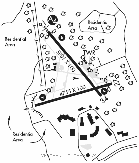
RWY16–34:H5001X100 (ASPH–GRVD) S–30, D–55, 2D–103 MIRL 0.5% up NW
RWY16: MALS. PAPI(P4L)–GA 3.5° TCH 41′. Thld dsplcd 239′. Trees.
RWY 34: REIL.
RWY 09–27: H4755X100 (ASPH–GRVD) S–30, D–114, 2S–145, 2D–180 MIRL 0.4% up E
RWY 09: PAPI(P4L)–GA 3.0° TCH 43′. Tree.
RWY 27: PAPI(P4L)–GA 3.22° TCH 46′. Thld dsplcd 250′. Trees.
LAND AND HOLD–SHORT OPERATIONS
LDG RWY HOLD–SHORT POINT AVBL LDG DIST
RWY 09 16–34 3450
RWY 16 09–27 4000
SERVICE: S4 FUEL 100LL, JET A, A+ OX 3, 4 LGT Rwy 16 nstd MALS–800 ft. When twr clsd ACTVT MALS Rwy 16; REIL Rwy 34; PAPI Rwy 16, 09 and 27; MIRL Rwy 09–27 and Rwy 16–34–CTAF.
NOISE: Noise sensitive arpt. Voluntary compliance req of all acft exceeding 75 db to not land/depart arpt 0400–1200Z‡. Noise abatement procedures in effect ctc arpt manager 978–921–6072. All arrival/departure acft follow manufacturers recommended procedures for quiet ops and minimum noise. Noise sensitive area off the DER 27 to the W, SW, & S and off the DER 34 to the NW.
AIRPORT REMARKS: Attended 1330–2130Z‡. Birds frequently on or invof arpt, occasional deer or coyote on rwy. Fld cond not mnt 0200–1200Z‡ 15 May–31 Oct; 0100–1200Z‡ 01 Nov–14 May. Fuel svc 1030–2330Z‡, after hrs req only call 978–774–2070. Fuel, parking ctc FBO 129.725 or 978–774–2070. No ultralight or banner towing allowed. Rwy 16 is the preferred calm wind rwy. Rwy 16–34: due to hump at midpt, opposite ends of the rwy not vsb at gnd level. No tiedown ropes on public tsnt prkg. E ramp tsnt spaces: space nrs 15, 16 & 17 only. Ldg fees for transient acft. Overnight parking fee. Flight Notification Service (ADCUS) available.
AIRPORT MANAGER: 978-921-6072
WEATHER DATA SOURCES: ASOS 119.2 (978) 921–5042. LAWRS.
COMMUNICATIONS: CTAF 125.2 ATIS 119.2 UNICOM 122.95
®BOSTON APP/DEP CON 124.4
TOWER 125.2 (1200–0200Z‡ 15 May–31 Oct; 1200–0100Z‡ 01 Nov–14 May) GND CON 121.6
AIRSPACE: CLASS D svc 1200–0200Z‡ 15 May– 31 Oct, 1200–0100Z‡ 01 Nov– 14 May; other times CLASS G.
RADIO AIDS TO NAVIGATION: NOTAM FILE LWM.
LAWRENCE (L) DME 112.5 LWM Chan 72 N42°44.43′ W71°05.69′ 140° 12.3 NM to fld. 306.
DME unusable:
160°–195° byd 23 NM blo 2,500′
LOC/DME 110.5 I–BVY Chan 42 Rwy 16. LOC unusable byd 15° left of course. DME unusable byd 15° left of course.
COMM/NAV/WEATHER REMARKS: Emerg frequency 121.5 not available at twr. When twr not opn, close flight plan with Boston apch–121.6.