BURNET MUNI/KATE CRADDOCK FLD (BMQ)(KBMQ) 1 SW UTC–6(–5DT) N30°44.34′ W98°14.32′
1283 B NOTAM FILE BMQ
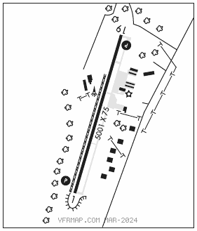
RWY 01–19: H5001X75 (ASPH) S–30 MIRL 0.5% up N
RWY 01: REIL. PAPI(P4L)—GA 3.0° TCH 43′. P–line. Rgt tfc.
RWY 19: REIL. PAPI(P4L)—GA 3.03° TCH 45′. Trees.
SERVICE: S4 FUEL 100LL, JET A LGT REIL RWY 01 and 19; PAPI RWY 01 and 19; MIRL Rwy 01–19 preset low INTST; to INCR INTST and ACTVT—CTAF.
AIRPORT REMARKS: Attended 1400–0000Z‡. For arpt attendant call 512–756–6655. Deer invof arpt. Rwy 19 preferred calm wind rwy.
AIRPORT MANAGER: 512-756-6655
WEATHER DATA SOURCES: ASOS 119.925 (512) 756–7277.
COMMUNICATIONS: CTAF/UNICOM 122.8
®HOUSTON CENTER APP/DEP CON 132.35
CLEARANCE DELIVERY PHONE: For CD ctc Houston ARTCC at 281-230-5622.
RADIO AIDS TO NAVIGATION: NOTAM FILE SJT.
GOOCH SPRINGS (H) (H) VORTACW 112.5 AGJ Chan 72 N31°11.13′ W98°08.51′ 186° 27.2 NM to fld. 1191/5E.