ROCKY MOUNTAIN METRO (BJC)(KBJC) 9 NW UTC–7(–6DT) N39°54.53′ W105°07.03′
5673 B ARFF Index–See Remarks NOTAM FILE BJC
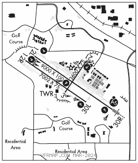
RWY 12L–30R: H9000X100 (ASPH–GRVD) S–65, D–105, 2S–95, 2D–150 PCN 31 F/D/W/T HIRL
RWY 12L: REIL. PAPI(P4L)–GA 3.0° TCH 41′. 1.0% down.
RWY 30R: MALSR. PAPI(P4L)–GA 3.0° TCH 52′. Rgt tfc. 1.1% up.
RWY 12R–30L: H7002X75 (ASPH–GRVD) S–47, D–61 PCN 18 F/D/X/T MIRL 1.1% up NW
RWY 12R: REIL. PAPI(P2L)–GA 3.0° TCH 40′. Rgt tfc.
RWY 30L: REIL. PAPI(P2L)–GA 3.0° TCH 41′.
RWY 03–21: H3600X75 (ASPH) S–40, D–45, 2D–65 MIRL 0.4% up S
RWY 03: PAPI(P2L)–GA 3.0° TCH 30′.
RWY 21: PAPI(P2L)–GA 3.0° TCH 40′. Rgt tfc.
RUNWAY DECLARED DISTANCE INFORMATION
RWY 03: TORA–3600 TODA–3600 ASDA–3600 LDA–3600
RWY 12L:TORA–9000 TODA–9000 ASDA–9000 LDA–9000
RWY 12R:TORA–7002 TODA–7002 ASDA–7002 LDA–7002
RWY 21: TORA–3600 TODA–3600 ASDA–3600 LDA–3600
RWY 30L:TORA–7002 TODA–7002 ASDA–7002 LDA–7002
RWY 30R:TORA–9000 TODA–9000 ASDA–9000 LDA–9000
SERVICE: S4 FUEL 100LL, JET A OX1, 2, 3, 4 LGT When ATCT clsd ACTVT MALSR Rwy 30R; REIL Rwy 12L, 12R and 30L; PAPI Rwy 03, 12L, 12R, 21, 30L and 30R; MIRL Rwy 03–21 and 12R–30L; HIRL Rwy 12L–30R–CTAF.
NOISE: Noise abatement proc in efct ctc noise office 303–271–4850.
AIRPORT REMARKS: Attended continuously. 100LL self svc. Birds and wildlife on and invof rwy. Hel arr/dep fm rwy and twys. Pilots are requested to avoid flt due to nesting eagles: Below 6500 ft MSL, BJC VOR 25 deg radial, 2.7 DME; Over Standley Lake below 8000 ft MSL, BJC VOR 150 deg radial, 3.0 DME. Class II ARFF Index A. 24 hr PPR for unsked acr ops with more than 30 pax seats–720–352–0395. ARFF Index B avbl PPR–720–352–0395. Twy C1 and Twy D mkd with reflectors. N trml ramp slp exceeds rcmdd std. Flight Notification Service (ADCUS) avbl. NOTE: See Special Notices–Extensive Helicopter Flight Training. See Special Notices–USAF 306 FTG Flight Training Areas, Vicinity of Colorado Springs and Pueblo Colorado. See Special Notices–Arrival Alert.
AIRPORT MANAGER: (303) 271-4851
WEATHER DATA SOURCES: AWOS–3 (720) 887–8067
COMMUNICATIONS: CTAF 118.6 ATIS 126.25 303–466–8744
DENVER APP/DEP CON 125.12
METRO TOWER 118.6 (1300–0500Z‡) GND CON 121.7 CLNC DEL 132.6
AIRSPACE: CLASS D svc 1300–0500Z‡; other times CLASS G.
RADIO AIDS TO NAVIGATION: NOTAM FILE BJC.
JEFFCO (VH) (DH) VORW/DME 115.4 BJC Chan 101 N39°54.78′ W105°08.34′ 093° 1.0 NM to fld. 5737/11E.
VOR unusable:
180°–225° byd 40 NM
226°–245° byd 36 NM blo 17,000′
246°–278° byd 30 NM blo 19,000′
279°–300° byd 34 NM blo 18,000′
301°–335° byd 40 NM
DME unusable:
246°–278° byd 30 NM
ILS 111.7 I–BJC Rwy 30R. Class IA. Unmonitored when ATCT closed.
COMM/NAV/WEATHER REMARKS: Emerg frequency 121.5 not avbl at twr.