BANGOR
BANGOR INTL (BGR)(KBGR) P (ANG ARNG) 3 W UTC–5(–4DT) N44°48.45′ W68°49.69′ 192 B TPA–See Remarks LRA ARFF Index–See Remarks NOTAM FILE BGR
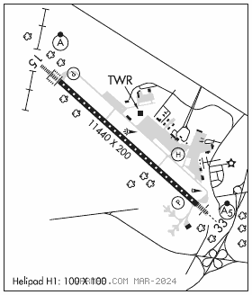
RWY 15–33: H11440X200 (ASPH–GRVD) S–100, D–210, 2D–400 PCN 120R/A/W/T HIRL CL
RWY 15: ALSF2. TDZL. PAPI(P4L)–GA 3.0° TCH 55′. RVR–TMR 0.4% down.
RWY 33: MALSR. PAPI(P4L)–GA 3.0° TCH 57′. RVR–TMR Trees.
RUNWAY DECLARED DISTANCE INFORMATION
RWY 15: TORA–11440 TODA–11440 ASDA–11440 LDA–11440
RWY 33: TORA–11440 TODA–11440 ASDA–11440 LDA–11440
SERVICE: S4 FUEL 100LL, JET A OX 2, 4 MILITARY– JASU 1(MD–3) 1(MC–11) (MA–1A) FUEL A++(Mil), A, A+ (C207–992–4600) (NC–100LL) FLUID SP PRESAIR LPOX LOX –Off–base contracted LOX avbl H24–rqr 24 hr notice. OIL O–133–148(Mil)
AIRPORT REMARKS: Attended continuously. TPA for turbo jet acft is 2000(1808) unless otherwise instructed. ARFF Index B with Index E capabilities avbl 24/7. Flight Notification Service (ADCUS) available.
MILITARY REMARKS: Transient acft may be diverted to civilian side during non–duty hrs & weekends. Fee required; no ANG transient alert.
CAUTION Bash Phase II period Sep–Nov, Apr–May. Expect increased bird activity. Ctc Base Ops/Command Post/SOF for current bird watching cond. MISC Rwy 15–33 grooved. ANG Opr 1100–1930Z‡ Mon–Fri, clsd weekends and hol. PPR rqr for ANG ramp. Ctc afld mgmt DSN 698–7232, C207–404–7232 for PPR dur opr hrs. Pre–coord all transportation requirements and and haz cargo with PPR rqr. PPR valid +/– 1 hr unless prior coord. 3 hr out call, 30 min out call 311.0 to CFM customs/AG and tran svc. Comd post C207–404–7788 24 hrs. ARNG Opr 1230–2100Z‡ Mon–Fri exc hol. Ltd maint. J8. PPR May–Oct svc DSN 626–1100.
AIRPORT MANAGER: 207-992-4600
WEATHER DATA SOURCES: ASOS 127.75 (207) 561–2515.
COMMUNICATIONS: ATIS 127.75 (207–561–2524) UNICOM 122.95
RCO 122.2 (BANGOR RADIO)
®APP/DEP CON 118.925 124.5
TOWER 120.7 GND CON 121.9 CLNC DEL 135.9
AIRSPACE: CLASS C svc ctc APP CON.
RADIO AIDS TO NAVIGATION: NOTAM FILE BGR.
(VH) (H) VORTACW 114.8 BGR Chan 95 N44°50.51′ W68°52.44′ 155° 2.8 NM to fld. 36019W.
ILS/DME 109.5 I–JVH Chan 32 Rwy 15. Class IIIE. DME also serves Rwy 33.
ILS/DME 109.5 I–BGR Chan 32 Rwy 33. Class IIE. DME also serves Rwy 15. DME unusable byd 26° r of course.
ASR
• • • • • • • • • • • • • • • • • •
HELIPAD H1: H100X100 (CONC)