MEADOWS FLD (BFL)(KBFL) 3 NW UTC–8(–7DT) N35°26.03′ W119°03.46′
510 B ARFF Index–See Remarks NOTAM FILE BFL
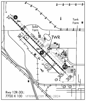
RWY 12L–30R: H10849X150 (ASPH–GRVD) S–96, D–155, 2S–175, 2D–260, 2D/2D2–654 PCN 38 F/B/X/T HIRL CL
RWY 12L: PAPI(P4L)–GA 3.0° TCH 50′. RVR–TMR 0.4% down.
RWY 30R: MALSR. TDZL. PAPI(P4L)–GA 3.0° TCH 51′. RVR–TMR Thld dsplcd 3419′. Rgt tfc. 0.3% up.
RWY 12R–30L: H7700X100 (ASPH) S–18 PCN 14 F/B/X/U MIRL 0.3% up NW
RWY 12R: REIL. PAPI(P4L)–GA 3.0° TCH 25′. Rgt tfc.
RWY 30L: REIL. PAPI(P4L)–GA 3.0° TCH 25′. Thld dsplcd 1499′. Tree.
RUNWAY DECLARED DISTANCE INFORMATION
RWY 12L:TORA–10848 TODA–10848 ASDA–10848 LDA–10848
RWY 12R:TORA–7703 TODA–7703 ASDA–7703 LDA–7703
RWY 30L:TORA–7703 TODA–7703 ASDA–7703 LDA–6203
RWY 30R:TORA–10848TODA–10848 ASDA–10848 LDA–7429
SERVICE: S4 FUEL 100, 100LL, JET A OX 4 LGT When ATCT clsd ACTIVATE MALSR Rwy 30R; PAPI Rwy 12L and 30R; HIRL Rwy 12L–30R; twy lgts–CTAF. Rwy 12R–30L clsd when ATCT clsd.
NOISE: Noise sensitive areas South and East of arpt recommended turbojet trng hrs weekdays 1600–0600Z‡, weekends 2000–0600Z‡ no more than ten practice apchs per hr.
AIRPORTREMARKS: Attended continuously. Rwy 12R–30L CLOSED when twr clsd. Right base ops for Rwy 30R establish wings level on final apch no lower than 300′ AGL. Arpt ops not authorized blo 1200 RVR without SMGCS. Arpt ops not initiated blo 600 RVR or authorized blo 500 RVR. Rwy 30R 50:1 to dspld thld. Class I, ARFF Index B. Index C ARFF avbl.
AIRPORT MANAGER: 661-391-1824
WEATHER DATA SOURCES: ASOS (661) 393–3766
COMMUNICATIONS: CTAF 118.1 ATIS 118.6 661–399–9425 UNICOM 122.95
®BAKERSFIELD APP CON 118.9 (North) 118.8 (South) (1400–0700Z‡)
®BAKERSFIELD DEP CON 126.45 (North/South) (1400–0700Z‡)
®L.A. CENTER APP/DEP CON 127.1 (0700–1400Z‡)
BAKERSFIELD TOWER 118.1 (1400–0700Z‡) GND CON 121.7
AIRSPACE: CLASS D svc 1400–0700Z‡; other times CLASS E.
VOR TEST FACILITY (VOT) 111.2
RADIO AIDS TO NAVIGATION: NOTAM FILE BFL.
SHAFTER (VH) (H) VORTACW 115.4 EHF Chan 101 N35°29.07′ W119°05.84′ 133° 3.6 NM to fld. 549/14E.
VOR unusable:
029°–106° byd 40 NM
108°–131° byd 40 NM
132°–142° byd 40 NM blo 10,000′
132°–142° byd 70 NM
153°–180° byd 40 NM
232°–249° byd 40 NM
327°–347° byd 40 NM blo 9,000′
327°–347° byd 67 NM blo 18,000′
ILS/DME 111.9 I–BFL Chan 56 Rwy 30R. Class IE. Unmonitored when ATCT clsd. LOC unusable byd 25° left and r of course.