SCOTTSBLUFF
WESTERN NEBRASKA RGNL/WILLIAM B HEILIG FLD (BFF)(KBFF) 3 E UTC–7(–6DT) N41°52.44′ W103°35.74′ 3967 B ARFF Index–See Remarks NOTAM FILE BFF MON Airport
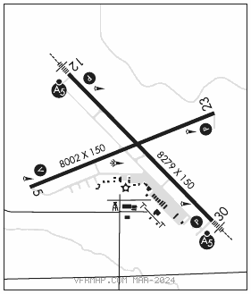
RWY 12–30: H8279X150 (ASPH) S–109, D–178, 2S–139, 2D–321 PCN 42 F/A/W/T HIRL
RWY 12: MALSR. PAPI(P4L)–GA 3.0° TCH 57′.
RWY 30: MALSR. PAPI(P4L)–GA 3.0° TCH 53′.
RWY 05–23: H8002X150 (ASPH) S–98, D–158, 2D–285 PCN 37 F/A/W/T MIRL
RWY 05: VASI(V4L)–GA 3.0° TCH 50′.
RWY 23: PAPI(P4L)–GA 3.0° TCH 52′. Road.
RUNWAY DECLARED DISTANCE INFORMATION
RWY 05: TORA–8002 TODA–8002 ASDA–8002 LDA–8002
RWY 12: TORA–8279 TODA–8279 ASDA–8279 LDA–8279
RWY 23: TORA–8002 TODA–8002 ASDA–8002 LDA–8002
RWY 30: TORA–8279 TODA–8279 ASDA–8279 LDA–8279
SERVICE: S4 FUEL 100LL, JET A OX 2 LGT ACTIVATE MIRL Rwy 05–23, HIRL Rwy 12–30, MALSR Rwy 12 and Rwy 30, and VASI Rwy 05, PAPI Rwy 12, Rwy 23 and Rwy 30–CTAF.
AIRPORT REMARKS: Attended 1300–0400Z‡. For svc after hrs call 308–635–0162. Waterfowl on and invof arpt. Rwy 30 designated calm wind rwy. Line of site restrictions between apch ends of Rwy 05 and Rwy 30 and also between the apch ends of Rwy 12 and Rwy 23. Apron pavement strength, S–85, D–117, DT–232. PCN is 31 R/A/W/T. Class I, ARFF Index A. PPR 24 hrs for air carrier ops with more than 30 passenger seats call arpt manager 308–635–4941. Air carrier ops over 9 passenger seats not authorized in excess of 15 minutes before or after scheduled arrival/departure times except with prior coordination with arpt manager. ARFF index B equipment is provided. Per arpt manager use CTAF when operating on the arpt. AC and DC ground power units available. Lavatory service available.
AIRPORT MANAGER: (308) 631-7449
WEATHER DATA SOURCES: ASOS 121.025 (308) 632–8949.
COMMUNICATIONS: CTAF/UNICOM 123.0
RCO 122.1R 112.6T (COLUMBUS RADIO)
SCOTTSBLUFF RCO 122.6 (COLUMBUS RADIO)
®DENVER CENTER APP/DEP CON 127.95
CLEARANCE DELIVERY PHONE: For CD ctc Denver ARTCC on freq. If una, ctc FSS on freq via rco. If una, ctc Denver ARTCC at 303-651-4257.
AIRSPACE: CLASS E.
RADIO AIDS TO NAVIGATION: NOTAM FILE BFF.
SCOTTSBLUFF (VH) (H) VORTAC 112.6 BFF Chan 73 N41°53.65′ W103°28.92′ 244° 5.2 NM to fld. 4169/13E.
TACAN AZIMUTH unusable:
025°–060° byd 25 NM blo 6,300′
310°–025° byd 25 NM blo 6,500′
DME unusable:
025°–060° byd 25 NM blo 6,300′
310°–025° byd 25 NM blo 6,500′
VOR unusable:
062°–072° byd 40 NM
129°–145° byd 40 NM blo 7,000′
129°–145° byd 58 NM
162°–172° byd 40 NM
177°–187° byd 40 NM
ILS/DME 110.35 I–RMT Chan 40(Y) Rwy 12. Class IB. LOC unusable wi 0.3 NM to thld.
ILS/DME 109.3 I–BFF Chan 30 Rwy 30. Class IB. LOC unusable 0.3 NM to thld; byd 16° left of course; byd 25° right of course.