BOYNE MOUNTAIN (BFA)(KBFA) 1 W UTC–5(–4DT) N45°09.95′ W84°55.45′
719 NOTAM FILE LAN
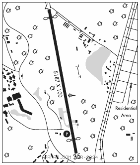
RWY 17–35: H5187X100 (ASPH–GRVD) MIRL 0.3% up S
RWY 17: REIL. Thld dsplcd 300′. Road.
RWY 35: REIL. PAPI(P2L)—GA 3.0° TCH 40′. Thld dsplcd 500′. Trees.
SERVICE: FUEL 100LL LGT Actvt REIL Rwy 17 & 35; PAPI Rwy 35; MIRL Rwy 17–35—122.85.
AIRPORTREMARKS: Attended 1300–2100Z‡ . Deer & birds on & invof arpt. Pedestrians invof rwy environment. 100LL no self svc avbl. For ldg fees ctc AMGR for details.
AIRPORT MANAGER: 231-549-6852
WEATHER DATA SOURCES: AWOS–3PT 118.675 (231) 330–8677.
COMMUNICATIONS: CTAF/UNICOM 122.8
®MINNEAPOLIS CENTER APP/DEP CON 134.6
CLEARANCE DELIVERY PHONE: For CD ctc Minneapolis ARTCC at 651-463-5588.
RADIO AIDS TO NAVIGATION: NOTAM FILE PLN.
PELLSTON (L) (L) VORTACW 111.8 PLN Chan 55 N45°37.84′ W84°39.85′ 208° 30.0 NM to fld. 836/6W.
VOR unusable:
301°–339°
GCP has azm only, no DME at GCP