BEDFORD
LAURENCE G HANSCOM FLD (BED)(KBED) P (AF) 0 NE UTC–5(–4DT) N42°28.20′ W71°17.34′ 132 B TPA–See Remarks Class I, ARFF Index B NOTAM FILE BED
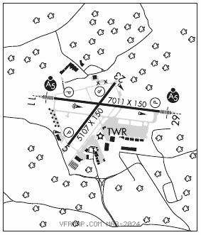
RWY 11–29: H7011X150 (ASPH–GRVD) S–120, D–250, 2S–127, 2D–455 PCN 82 F/C/W/T HIRL
RWY 11: MALSR. PAPI(P4L)–GA 3.0° TCH 67′. RVR–T Hill.
RWY 29: MALSR. PAPI(P4R)–GA 3.0° TCH 52′. RVR–R
RWY 05–23: H5107X150 (ASPH–GRVD) S–120, D–250, 2S–149, 2D–436 PCN 79 F/C/W/T MIRL
RWY 05: REIL. PAPI(P4L)–GA 3.5° TCH 55′.
RWY 23: REIL. PAPI(P4R)–GA 3.2° TCH 55′.
LAND AND HOLD–SHORT OPERATIONS
LDG RWY HOLD–SHORT POINT AVBL LDG DIST
RWY 05 11–29 3000
RWY 11 05–23 2650
RWY 29 05–23 3662
RUNWAY DECLARED DISTANCE INFORMATION
RWY 05: TORA–5107 TODA–5107 ASDA–5107 LDA–5107
RWY 11: TORA–7011 TODA–7011 ASDA–7011 LDA–7011
RWY 23: TORA–5107 TODA–5107 ASDA–5107 LDA–5107
RWY 29: TORA–7011 TODA–7011 ASDA–7011 LDA–7011
SERVICE: S4 FUEL 100LL, JET A OX 1, 2, 3, 4 LGT Actvt MALSR Rwy 11 and 29; REIL Rwy 05 and 23; HIRL Rwy 11–29; MIRL Rwy 05–23; twy lgts–118.5. MILITARY– JASU 3(A/M32A–86) 2(MA–1A) FUEL 100LL, A TRAN ALERT Opr 1200–0400Z‡ wkd; 1400–2200Z‡ Sun; PPR OT and hol DSN 845–5589/5592. De–icing avbl fr vendor. Ltd hgr space and extremely ltd maint. Fleet svc avbl fr vendor. Mil acft must arng for prkg on east ramp with tran alert or vendor.
NOISE: Noise rules in effect, helicopters opr within controlled airspace are rqrd to maintain highest possible alt. Voluntary noise abatement procs in efct ctc amgr 671–212–6592. Noise sensitive historic area S of arpt; for Rwy 23 dep cont rwy hdg to 1000 ft AGL, turning crosswind ovr Rte 2.
AIRPORT REMARKS: Attended continuously. Birds and wildlife on and invof arpt. PPR for all acft carrying explosives call 617–212–6592. PPR for maint eng run–ctc amgr. No plas/tgls for acft 12,500 lbs and over. No plas/tgls for acft under 12,500 lbs 0400–1200Z‡. Be alert for small acft parked on ramps. Rwy 29 right tfc acft over 12,500 lbs. TPA–1132(1000) fixed wing, 1632(1500) turbojet, 1932(1800) heavy jet acft. Clsd to Part 121 ACR ops with over 60 seats excp 24 hr PPR call 781–869–8000. Twy C, F, J, N, R, S, T, Twy M south of Twy E & Twy G btn Rwy 11–29 & Rwy 05–23 clsd to acft gtr than 118 ft wingspan. Twy R clsd to ACR ops–GA use only. Twy R1, R2 clsd to acft gtr than 49 ft wingspan. Surcharge for each ldg and dep 0400–1200Z‡. Coml and tsnt ldg fee. Flight Notification Service (ADCUS) avbl. User fee arpt. NOTE: See Special Notices–Arrival Alert.
AIRPORT MANAGER: 617-212-6592
WEATHER DATA SOURCES: ASOS 124.6 (781) 372–5512. LAWRS.
COMMUNICATIONS: CTAF 118.5 ATIS 124.6 (781) 372–5509 UNICOM 122.95
®BOSTON APP/DEP CON 124.4
HANSCOM TOWER 118.5 (1200–0400Z‡) GND CON 121.7 CLNC DEL 121.85
AIRSPACE: CLASS D svc 1200–0400Z‡; other times CLASS G.
VOR TEST FACILITY (VOT) 110.0
RADIO AIDS TO NAVIGATION: NOTAM FILE BOS.
BOSTON (VH) (DH) VOR/DME 112.7 BOS Chan 74 N42°21.45′ W70°59.37′ 313° 14.9 NM to fld. 18/16W.
VOR unusable:
043°–053° byd 40 NM blo 5,000′
043°–053° byd 74 NM
055°–065° byd 40 NM blo 5,000′
055°–065° byd 47 NM
061°–104° byd 18 NM blo 2,000′
070°–108° byd 40 NM
109°–119° byd 40 NM blo 6,000′
109°–119° byd 58 NM
120°–148° byd 40 NM
149°–167° byd 40 NM blo 2,100′
149°–167° byd 83 NM
168°–177° byd 40 NM
178°–188° byd 40 NM blo 11,000′
178°–188° byd 50 NM
204°–262° byd 40 NM
263°–273° byd 40 NM blo 4,000′
263°–273° byd 54 NM
271°–060° byd 25 NM blo 3,500′
274°–337° byd 40 NM
350°–042° byd 40 NM
DME unusable:
061°–104° byd 18 NM blo 2,000′
271°–060° byd 25 NM blo 3,500′
LAWRENCE (L) DME 112.5 LWM Chan 72 N42°44.43′ W71°05.69′ 208° 18.4 NM to fld. 306. NOTAM FILE LWM.
DME unusable:
160°–195° byd 23 NM blo 2,500′
ILS/DME 111.15 I–BED Chan 48(Y) Rwy 11. Class IA. Unmonitored when ATCT clsd.
ILS/DME 111.15 I–ULJ Chan 48(Y) Rwy 29. Class IA. Unmonitored when ATCT clsd.