WINDSOR LOCKS
BRADLEY INTL (BDL)(KBDL) P (ANG ARNG) 3 W UTC–5(–4DT) N41°56.34′ W72°41.06′ 173 B TPA–See Remarks LRA Class I, ARFF Index C NOTAM FILE BDL MON Airport
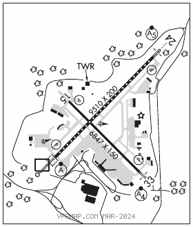
RWY 06–24: H9510X200 (ASPH–GRVD) S–200, D–200, 2S–175, 2D–350, 2D/2D2–710 PCN 71 F/B/X/T HIRL CL
RWY 06: ALSF2. TDZL. REIL. PAPI(P4L)–GA 3.0° TCH 71′. RVR–TMR Trees.
RWY 24: MALSR. TDZL. PAPI(P4L)–GA 3.0° TCH 71′. RVR–TMR Trees.
RWY 15–33: H6847X150 (ASPH–GRVD) S–200, D–200, 2S–175, 2D–350 PCN 64 F/A/X/T HIRL
RWY 15: REIL. PAPI(P4L)–GA 3.5° TCH 61′. RVR–R Trees.
RWY 33: MALSF. PAPI(P4R)–GA 3.0° TCH 72′. RVR–T Trees.
LAND AND HOLD–SHORT OPERATIONS
LDG RWY HOLD–SHORT POINT AVBL LDG DIST
RWY 24 15–33 5850
RWY 33 06–24 4550
RUNWAY DECLARED DISTANCE INFORMATION
RWY 06: TORA–9509 TODA–9509 ASDA–9509 LDA–9509
RWY 15: TORA–6847 TODA–6847 ASDA–6847 LDA–6847
RWY 24: TORA–9509 TODA–9509 ASDA–9509 LDA–9509
RWY 33: TORA–6847 TODA–6847 ASDA–6847 LDA–6847
SERVICE: S4 FUEL 100LL, JET A OX 1, 2, 3, 4 LGT Unmonitored when afld clsd. Afld ops ltd to tenant acft when afld clsd. MILITARY– JASU (MD)–3 FUEL A++(Mil) A, A+ (C860–627–3300.) (NC–100LL) FLUID SP LOX OIL O–128–133–148 (Mil) SOAP
AIRPORT REMARKS: Attended continuously. Numerous birds freq on or invof arpt. No trng flts, no practice apchs, no touch and go ldgs btn Mon–Sat 0400–1200Z‡ and Sun 0400–1700Z‡. BASH Phase II increased bird activity Sep–Oct and Mar–Apr. Solar panel farm located 1.5 miles south of Rwy 33 thld. All acft overflight of solar farm will be at or above 500′ AGL. Rwy 6 de–ice pad clsd to acft with wingspan 171′ or gtr exc with follow–me escort by arpt ops. Parl twy ops on Twy C and Twy B rstrd to acft with wingspans of 171′ or less. Twy D clsd btn S and D1 to acft with wing spans in excess of 170′. Twy C btn Twy B and Twy C4 acft tax spd rstrn of 8 kts/10 mph max for acft with wingspan 214′ or gtr. ASDE–X in use. Operate transponders with altitude reporting mode and ADS–B (if equipped) enabled on all airport surfaces. TPA–1873(1700) heavy acft. Fixed wing acft use low idle for taxi, no engine checks or power runs allowed on the Rwy 06–24 245′ by 200′ blast pad SW end. Rwy 15–33 100′ by 200′ blast pad SE end. Lgtd obst ant 36′ AGL/205′ MSL (Rwy 24 ILS/GS Ant) 162′ NW of Twy C cntrln marking btn Twy B and Twy C4. Non–based dvrsn acrs ctc arpt ops 860–627–3001 prior to divg & prvd co flt ops ctc info, acft type, POB, intl or dom flt & gnd ops agrmts. Only 1 intl acr jet bridge avbl for pax. Ldg fee for business, corporate and revenue producing acft. Flight Notification Service (ADCUS) avbl.
AIRPORT MANAGER: 860-292-2000
WEATHER DATA SOURCES: ASOS 118.15 (860) 386–3480. WSP.
COMMUNICATIONS: D–ATIS 118.15 (860–386–3570) UNICOM 122.95
®BRADLEY APP/DEP CON 123.95 (061°–240°) 125.35 (241°–060°) 127.225
TOWER 120.3 GND CON 121.9 CLNC DEL 121.75
CPDLC (LOGON KUSA)
PDC
AIRSPACE: CLASS C svc ctc APP CON.
VOR TEST FACILITY (VOT) 111.4
RADIO AIDS TO NAVIGATION: NOTAM FILE HFD.
HARTFORD (L) (L) VORW/DME 114.9 HFD Chan 96 N41°38.47′ W72°32.85′ 354° 18.9 NM to fld. 849/13W.
ILS/DME 111.1 I–BDL Chan 48 Rwy 06. Class IIIE.
ILS/DME 111.1 I–MYQ Chan 48 Rwy 24. Class IIE. DME unusable fm .4 NM inbd to Rwy 24.
ILS/DME 108.55 I–IKX Chan 22(Y) Rwy 33. Class IE.
ASR