BRANSON
BRANSON (BBG)(KBBG) 8 SSE UTC–6(–5DT) N36°31.92′ W93°12.03′ 1302 B Class I, ARFF Index B NOTAM FILE BBG
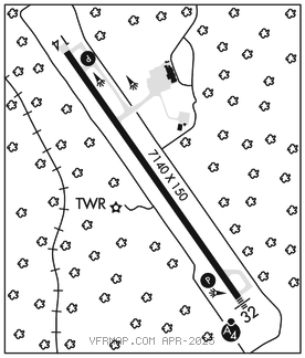
RWY 14–32: H7140X150 (CONC–GRVD) S–75, D–200, 2S–175, 2D–350, 2D/2D2–700 PCN 39 R/C/W/U HIRL 0.7% up SE
RWY 14: REIL. PAPI(P4L)–GA 3.0° TCH 51′. Rgt tfc.
RWY 32: MALSF. PAPI(P4L)–GA 3.0° TCH 50′.
RUNWAY DECLARED DISTANCE INFORMATION
RWY 14: TORA–7140 TODA–7140 ASDA–7140 LDA–7140
RWY 32: TORA–7140 TODA–7140 ASDA–7140 LDA–7140
SERVICE: FUEL 100LL, JET A, A+ LGT When ATCT clsd; ACTVT MALSF Rwy 32; REIL Rwy 14; PAPI Rwy 14 and 32; HIRL Rwy 14–32–CTAF.
AIRPORT REMARKS: Attended continuously. Birds invof arpt. 100LL credit card self svc avbl H24 at GA apron. Arpt clsd to unsked acr more than 30 pax seats exc 4 hr PPR–417–334–8002. PPR acr more than 15 min bfr or aft sked arr or dep–amgr. Rwy 32 calm wind rwy. Hills and uneven trrn invof; trrn avoidance may actvt on fnl.
AIRPORT MANAGER: 417-334-7813
WEATHER DATA SOURCES: AWOS–2 124.625 (417) 334–0218.
COMMUNICATIONS: CTAF 128.15 ATIS 124.625 UNICOM 122.95
®SPRINGFIELD APP/DEP CON 126.35
TOWER 128.15 (1300–0300Z‡) GND CON 118.4 CLNC DEL 118.4 126.35 (when twr clsd)
AIRSPACE: CLASS D svc 1300–0300Z‡; other times CLASS E.
RADIO AIDS TO NAVIGATION: NOTAM FILE HRO.
HARRISON (VL) (L) VORW/DME 112.5 HRO Chan 72 N36°19.10′ W93°12.80′ 359° 12.8 NM to fld. 14004E.
DME unusable:
245°–260° byd 30 NM blo 4,500′
VOR unusable:
000°–086° byd 40 NM
087°–097° byd 40 NM blo 3,000′
087°–097° byd 55 NM
098°–166° byd 40 NM
165°–215° byd 20 NM blo 5,000′
165°–215° byd 30 NM blo 6,500′
167°–177° byd 40 NM blo 10,000′
167°–177° byd 69 NM
178°–250° byd 40 NM
300°–359° byd 40 NM
ILS/DME 111.35 I–BBG Chan 50(Y) Rwy 32. Unmonitored when twr clsd.