ALVA RGNL (AVK)(KAVK) 2 S UTC–6(–5DT) N36°46.41′ W98°40.27′
1477 B NOTAM FILE AVK
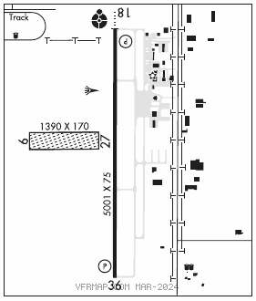
RWY 18–36: H5001X75 (CONC) MIRL
RWY 18: ODALS. PAPI(P4L)—GA 3.0° TCH 47′.
RWY 36: REIL. PAPI(P4L)—GA 3.0° TCH 40′.
RWY 09–27: 1390X170 (TURF) 0.3% up W
SERVICE: S4 FUEL 100LL, JET A LGT Actvt ODALS Rwy 18; REIL Rwy 36; MIRL Rwy 18–36—CTAF. PAPI Rwy 18 and 36 on consly.
AIRPORTREMARKS:Attended 1400–2300Z‡. 100LL fuel avbl H24 with 24 hr credit card.
AIRPORT MANAGER: 580-327-2898
WEATHER DATA SOURCES: AWOS–3PT 121.125 (580) 327–6778.
COMMUNICATIONS: CTAF/UNICOM 122.8
®VANCE APP/DEP CON 126.75 (1300–0200Z‡ wkd, 1900–2300Z‡ Sun; clsd Sat & federal hol. Gnd ctl and clnc del svc avbl 15 min prior to afld opening. Other times by NOTAM)
®KANSAS CITY CENTER APP/DEP CON 127.8 (0200–1300Z‡ wkd, 2300–1900Z‡ Sun; 24 Sat & federal hol. Gnd ctl and clnc del svc avbl 15 min prior to afld opening)
CLEARANCE DELIVERY PHONE: For CD ctc Vance Apch at 580-213-6765. When Vance Apch is clsd, ctc Kansas City ARTCC at 913-254-8508.
RADIO AIDS TO NAVIGATION: NOTAM FILE WDG.
WOODRING (T) (T) VORW/DME 109.0 ODG Chan 27 N36°22.43′ W97°47.29′ 292° 48.9 NM to fld. 1151/8E.