NASHUA
BOIRE FLD (ASH)(KASH) 3 NW UTC–5(–4DT) N42°46.94′ W71°30.85′ 200 B NOTAM FILE ASH
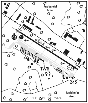
RWY 14–32: H6000X100 (ASPH–GRVD) S–62, D–80, 2S–102, 2D–133 HIRL
RWY 14: MALSR. PAPI(P4R)–GA 3.0° TCH 45′. Tree.
RWY 32: REIL. PAPI(P4L)–GA 3.0° TCH 45′. Thld dsplcd 350′. Tree.
RUNWAY DECLARED DISTANCE INFORMATION
RWY 14: TORA–6000 TODA–6000 ASDA–5650 LDA–5650
RWY 32: TORA–6000 TODA–6000 ASDA–6000 LDA–5650
SERVICE: S4 FUEL 100LL, JET A1+ OX 1, 2, 3, 4 LGT When twr clsd ACTVT MALSR Rwy 14; REIL Rwy 32; PAPI Rwy 14; HIRL Rwy 14–32–CTAF.
NOISE: Arpt has voluntary noise abatement procedures. Ctc arpt manager for details.
AIRPORT REMARKS: Attended 1200–0200Z‡. Migratory birds and wildlife on and invof arpt. Ramp btn Twy D & Twy E clsd to acft with wingspan gtr than 48 ft unless auzd by ATCT. Ldg fee for acft ovr 12,500 lbs, fee per 1000 lbs.
AIRPORT MANAGER: 603-882-0661
WEATHER DATA SOURCES: AWOS–3PT 125.1 (603) 578–0473.
COMMUNICATIONS: CTAF 133.2 ATIS 125.1
®BOSTON APP/DEP CON 124.9
NASHUA TOWER 133.2 (1200–0200Z‡) GND CON 121.8 CLNC DEL 121.8
AIRSPACE: CLASS D svc 1200–0200Z‡; other times CLASS G.
RADIO AIDS TO NAVIGATION: NOTAM FILE MHT.
MANCHESTER (L) (L) VORW/DME 114.4 MHT Chan 91 N42°52.11′ W71°22.17′ 246° 8.2 NM to fld. 47015W.
LAWRENCE (L) DME 112.5 LWM Chan 72 N42°44.43′ W71°05.69′ 278° 18.7 NM to fld. 306. NOTAM FILE LWM.
DME unusable:
160°–195° byd 23 NM blo 2,500′
ILS 109.7 I–ASH Rwy 14. Class IA. Glideslope unusable byd 4 ° left of course. Unmonitored when ATCT clsd.