ASPEN–PITKIN CO/SARDY FLD (ASE)(KASE) 3 NW UTC–7(–6DT) N39°13.31′ W106°52.09′
7838 B TPA–See Remarks Class I, ARFF Index B NOTAM FILE ASE
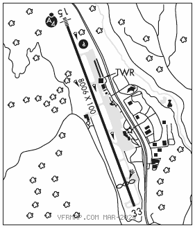
RWY 15–33: H8006X100 (ASPH–GRVD) S–80, D–100, 2D–160 PCN 28 F/B/X/U MIRL
RWY 15: MALSF. REIL. PAPI(P4L)–GA 3.5° TCH 55′. 1.9% up.
RWY 33: REIL. Thld dsplcd 1000′. Road. Rgt tfc. 2.0% down.
RUNWAY DECLARED DISTANCE INFORMATION
RWY 15: TORA–7006 TODA–7006 ASDA–7006 LDA–7006
RWY 33: TORA–8006 TODA–8006 ASDA–8006 LDA–7006
SERVICE: S2 FUEL 100LL, JET A1+ OX 1, 3 LGT Bcn lgts ops dusk–0600Z‡. When ATCT clsd ACTVT MALSF Rwy 15; REIL Rwy 33; PAPI Rwy 15; MIRL Rwy 15–33–CTAF. REIL Rwy 15–ATCT ctl, oper day VFR only. Rwy 15 PAPI unusbl byd 4 NM fm rwy thr and byd 7 deg rgt of rwy cntrln.
NOISE: NS ABTMT procedures in effect, ctc arpt ops 970–920–5760 ext 0.
AIRPORT REMARKS: Attended 1400–0600Z‡. Arpt CLOSED 0600–1400Z‡. Birds and other wildlife on and invof rwys. Watch for wildlife on or near rwys. Wind cones lctd 60 ft west of Twy A cntrln. CAUTION: High tfc intxn – acft rtnely hold short of Twy A4 on Twy A when inbd to trml or general aviation ramp. All arriving acft from 2000 to 2300 local must announce CTAF 118.85 when they are 20, 15, 10 and 5 miles out and on short final. Equipment may be on the rwy. Rwy 00X exists to support the PKN LDA assoc with this arpt. For acft svc ctc UNICOM. Hang gliders, para gliders, hot air balloons and glider ops on and invof arpt up to 18,000′ MSL. All commercial acft advise prior to pushback onto Twy A. Arpt lctd in high mountain valley with mountainous terrain from 12,500′–14,000′ MSL in near proximity to arpt, numerous unlgtd obst. All adverse wx situations magnified in mountains. Arpt rstd to max acft wingspan of 95′. Ops dur periods of reduced visibility discouraged for pilots unfamiliar with area. Unless ceilings are at least 2000′ abv highest terrain and visibility is 15 miles or more, mountain flying is not recommended. Due to high apch minimums pilots may need an IFR alternate even though wx is forecast to be higher than 2000′–3,000′. Terrain will not allow for normal tfc patterns. High rates of descent may be rqrd due to terrain and lcl procedures. Unique VFR dep procedures exist, call arpt ops 970–920–5760, or FBO 970–920–2016 for more info. FBO rqr 2 hrs advance ntc for staging acft prior to dep. For all general aviation ops btn 30 min after SS to 0600Z‡ the following applies, acft equipped as rqrd under FAR 91.205(D) for instr flt, pilot is instrument rated, VFR pilot–in–command has completed at least one tkf or ldg in the preceding 12 months at ASE. IFR, execute apch/dep procedures with ATC clnc. Acft rqrg IFR should file flt plan with flt svc 45 min prior to estimated dep. PPR for tkf on Rwy 15 ctc FBO 970–920–2016. Review of airplane performance recommended incl density altitude, weight and balance and climb performance. Due to poor visibility in valley, use ldg lgts in tfc pat. TPA for light acft 9023(1185), TPA for heavy ACFT 9523(1685). Unctl tfc on the ramps. Rwy 33 run–up area not visible from twr. Pilots are responsible for pax in ramp area. Pedestrians and vehicles cannot enter twys without ATC clnc. Stay on the solid side of the red boundary marking line. Cold temperature airport. Altitude correction required at or below –22C. Ldg fee. NOTE: See Special Notices–Special Procedures Aspen County/Sardy Field (KASE) Aspen, Colorado, "Cozy One VFR Departure (KASE)".
AIRPORT MANAGER: (970) 429-2851
WEATHER DATA SOURCES: ASOS 120.4 (970) 205–2482. LAWRS.
COMMUNICATIONS: CTAF 118.85 ATIS 120.4 UNICOM 122.95 ® APP/DEP CON 123.8 (1400–0300Z‡)
®DENVER CENTER APP/DEP CON 119.85 (0300–1400Z‡)
TOWER 118.85 (1400–0300Z‡) GND CON 121.9 CLNC DEL 123.75
AIRSPACE: CLASS D svc 1400–0300Z‡; other times CLASS E.
RADIO AIDS TO NAVIGATION: NOTAM FILE DEN.
RED TABLE (VH) (DH) VORW/DME 113.0 DBL Chan 77 N39°26.36′ W106°53.68′ 163° 13.1 NM to fld. 1180012E.
VOR unusable:
040°–056° byd 40 NM
057°–074° byd 40 NM blo 16,300′
057°–074° byd 65 NM
075°–100° byd 40 NM
115°–130° byd 40 NM
160°–200° byd 40 NM
LDA 108.5 I–PKN Rwy 00X. Localizer course width: 6.00 reverse sensing. This facility will be used as a departure NAVAID and a missed approach NAVAID. LDA sensing will be reversed. LDA 108.5 I–PKN available for missed approach/departures only. LDA unusable byd 25° back left/south of course. LDA unusable byd 30° back right/north of course.
LOC/DME 111.15 I–ASE Chan 48(Y) Rwy 15. LOC front unusable byd 14 NM blw 12,500′; byd 25° left and right of course. DME unusable byd 14 NM blw 12,500′; byd 25° left and right of course.
COMM/NAV/WEATHER REMARKS: Primary radar not avbl. Radar tfc advisories and svcs avbl for transponder equipped acft only. LDA 108.5 I–PKN avbl for missed apch/dep only. LDA unmonitored when twr clsd. LDA unusable byd 30° south of crs.