WHARTON RGNL (ARM)(KARM) 5 SW UTC–6(–5DT) N29°15.26′ W96°09.26′
100 B NOTAM FILE ARM
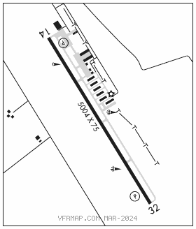
RWY 14–32: H5004X75 (ASPH) S–22 MIRL
RWY 14: PAPI(P4L)—GA 3.0° TCH 42′. Railroad. Rgt tfc.
RWY 32: PAPI(P4L)—GA 3.0° TCH 42′.
SERVICE: S4 FUEL 100LL, JET A+ LGT MIRL Rwy 14–32 preset to low intst; to incr intst and actvt—CTAF. PAPI Rwy 14 and Rwy 32 opr consly.
AIRPORT REMARKS: Attended Mon–Sat 1400–2300Z‡. Otr times on req, call–in fee waived with min fuel purchase. Hang gldr actvt wi 5 NM of arpt up to 6000′ AGL. Hang gldr towing opns in grassy area left of DER 14. 100LL & Jet A self serve. Jet A also by truck. Svrl rwy/twy lgts out. Rwy 14–32 pavement cracking, svrl areas where pavement lip exceeds 3 inches.
AIRPORT MANAGER: 979-532-3210
WEATHER DATA SOURCES: AWOS–3 118.475 (979) 532–2791.
COMMUNICATIONS: CTAF/UNICOM 122.7
®HOUSTON CENTER APP/DEP CON 128.6
CLEARANCEDELIVERYPHONE:For CD ctc Houston ARTCC at 281-230-5622.
RADIO AIDS TO NAVIGATION: NOTAM FILE ELA.
EAGLE LAKE (DH) DME 116.4 ELA Chan 111 N29°39.75′ W96°19.03′ 161° 25.9 NM to fld. 192.