DEER PARK (DEW)(KDEW) 3 NE UTC–8(–7DT) N47°58.02′ W117°25.72′
2211 B TPA–See Remarks NOTAM FILE DEW
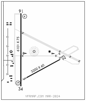
RWY 16–34: H6101X75 (ASPH) S–30, D–50 MIRL 0.4% up NW
RWY 16: REIL. PAPI(P4L)–GA 3.5° TCH 38′. Trees.
RWY 34: REIL. PAPI(P4L)–GA 3.0° TCH 40′.
RWY 05–23: H3200X60 (ASPH) S–12.5 PCN 17 F/C/W/T
SERVICE: S4 FUEL 100LL, JET A LGT ACTIVATE REIL Rwy 16 and Rwy 34; MIRL Rwy 16–34–CTAF. PAPI Rwy 16 and 34 opr continuously.
NOISE: NS ABTMT procedures in effect ctc arpt mgr 509–276–3379.
AIRPORT REMARKS: Attended Apr–Oct 1600–0100Z‡, Nov–Mar 1800–0000Z‡. 100LL and Jet A avbl 24 hrs credit card self svc facility. Call ahead for full svc, Jet A svc 509–276–3379. Rwy 05–23 heavy glider activity weekends. Model airplane activity on arpt. Farming opr active on land adjacent to rwys. Coyotes on and invof rwys. Monitor glider tfc on 123.3 abv 5000′ MSL. Glider pattern TPA 3211(1000). 175′ twr 2000′ west of Rwy 16–34. Rwy 16 preferred calm wind rwy.
AIRPORT MANAGER: 509-276-3379
WEATHER DATA SOURCES: ASOS 135.175 (509) 276–2303.
COMMUNICATIONS: CTAF/UNICOM 123.0
®SPOKANE APP/DEP CON 123.75
CLEARANCE DELIVERY PHONE: For CD ctc Spokane Apch at 509-742-2522
AIRSPACE: CLASS E.
RADIO AIDS TO NAVIGATION: NOTAM FILE GEG.
SPOKANE (VH) (H) VORTACW 115.5 GEG Chan 102 N47°33.90′ W117°37.61′ 004° 25.4 NM to fld. 2756/14E.
VOR unusable:
007°–022° byd 26 NM blo 7,000′
029°–041° byd 40 NM
307°–337° byd 30 NM blo 9,000′
342°–007° byd 18 NM blo 7,000′
342°–007° byd 25 NM
NDB (MHW) 365 DPY N47°58.06′ W117°25.58′ at fld. 2194/16E. NOTAM FILE DEW. NDB unmonitored.