SAUK/PRAIRIE (91C) 2 W UTC–6(–5DT) N43°17.87′ W89°45.35′
832 B NOTAM FILE GRB
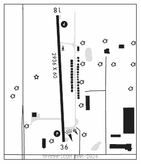
RWY 18–36: H2936X60 (ASPH) MIRL 0.4% up N
RWY 18: REIL. PAPI(P2L)—GA 3.0° TCH 26′.
RWY 36: REIL. PAPI(P2L)—GA 3.0° TCH 26′.
SERVICE: FUEL 100LL, UL94 LGT ACTIVATE MIRL Rwy 18–36; REIL Rwys 18 and 36; PAPI Rwy 18 and Rwy 36—CTAF.
AIRPORT REMARKS: Unattended. Ultralight activity on and invof arpt. Tkofs and ldgs are prohibited on unpaved sfcs. Maintenance vehicle tfc on and invof arpt. West ramp and twy pvt, clsd transient. Avoid hospital/helipad 3,000 ft southeast of Rwy 36 thld. Rwy 18 deps climb to 1,800 ft MSL on rwy heading before turning east/southeast. Fuel: 100LL: 24 hr self svc fuel avbl with credit card.
AIRPORT MANAGER: 608-577-3754
COMMUNICATIONS: CTAF 122.9
®MADISON APP/DEP CON 135.45 (1200–0500Z‡)
®CHICAGO CENTER APP/DEP CON 133.3 (Hours Madison apch clsd)
CLEARANCE DELIVERY PHONE: For CD ctc Madison app/dep con at 608-249-8240. when Madison Apch clsd, for CD ctc Chicago ARTCC at 630-906-8921.
RADIO AIDS TO NAVIGATION: NOTAM FILE DLL.
DELLS (VH) (H) VORTAC 117.0 DLL Chan 117 N43°33.05′ W89°45.82′ 176° 15.2 NM to fld. 1023/3E.
VOR unusable:
008°–122° byd 40 NM
103°–114° byd 30 NM blo 17,000′
135°–148° byd 40 NM
165°–290° byd 40 NM
291°–301° byd 108 NM blo 14,500′
291°–301° byd 123 NM
291°–301° byd 40 NM blo 9,000′
302°–312° byd 40 NM blo 18,000′
313°–323° byd 40 NM blo 3,500′
313°–323° byd 66 NM
335°–339° byd 40 NM